Norwich unveils conceptual plan to remake Howard T. Brown waterfront with plazas, riverwalk and relocated boat launch
Loading...
Summary
SLR Consulting presented a conceptual master plan for Howard T. Brown Park and a segment of the Heritage Trail, showing plazas, a continuous riverwalk, a splash-pad/ice-rink plaza, a band shell and a proposed relocation of the boat launch; city officials said work could begin in spring if permitting and funding stay on track.
Norwich officials and their consultants presented a conceptual master plan for Howard T. Brown Park and a portion of the Heritage Trail during a City Council meeting, showing new plazas, an expanded riverwalk, a splash-play area convertible to an ice rink, a band shell and a proposed relocation of the boat launch.
Kevin Brown of NCDC introduced the project and described the work to date, saying the current presentation is a “conceptual design.” He told the council the city has assembled roughly $7,000,000 in grants and local contributions for waterfront improvements, and that SLR Consulting had been hired as the project’s master planner.
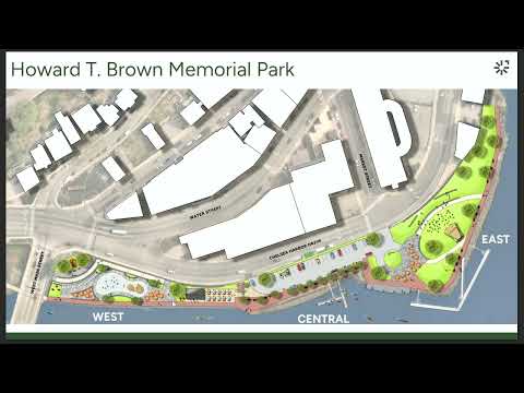
The plan presented by Mike Doherty, manager of landscape architecture with SLR Consulting, divides Howard T. Brown Park into west, central and east zones and proposes different improvements in each. “We’re really trying to activate the west side, reallocate space within the central area, and activate and remove pavement from the East Side,” Doherty said.
Key elements shown in the concept drawings:
- West plaza: an accessible ramp from West Main Street down to a new plaza with a multiuse spray-play fountain designed as flush jets, seating, shade trees and a restroom and mechanical/storage space tucked under an upper plaza. The plan envisions the fountain area converting to an ice-skating ribbon in winter.
- Central riverwalk: removal of the existing boat ramp in the central section to create a continuous riverwalk at about an 8-foot width for two-way pedestrian and bicycle traffic, with parallel spaces for small-craft pickup and drop-off and refurbished docks for kayaks, canoes and paddleboards.
- East event lawn: removal of large paved parking areas to create an event lawn, a band shell (open-sided with a large roof), and a food-truck/event plaza to activate waterfront-facing uses.
SLR described completed technical steps and near-term design work: a topographic and ground survey has been finished, wetland delineations were performed by the project ecologists, and the team held a pre-application meeting with the Connecticut Department of Energy and Environmental Protection. The consultant said the next deliverable is 20% schematic design, followed by preliminary order-of-magnitude costs and phasing; the team proposed an April 1, next-year construction start if permitting and procurement stay on schedule and targeted a finish near the following Christmas (the presenter cautioned that date could slip).
Officials discussed the proposed relocation of the existing boat launch to the viaduct parking lot. City staff said the state comptroller is negotiating to return roughly 40–50 parking spots the state no longer needs in that lot; the site would provide better maneuvering room for trailer boats and a roughly 14-foot drop to the Chautauqua where a new ramp could be built. The city said the timing of any ramp relocation depends on schematic design, cost estimates and whether additional grants are needed.
Council members asked about parking, lighting and maintenance. City staff estimated the park concept would result in a net loss of about 30 on-site parking spaces but noted there are often roughly that many spots available at any given time; officials pointed to the Market Street garage as an alternate parking resource for events. Lighting was described as an upgrade to pedestrian-style fixtures, operating on existing dusk-to-dawn timing unless otherwise decided. On annual operations and maintenance for the spray pad and skating elements, city staff said the costs were discussed during grant application meetings and “scoped… to an affordable level,” but an explicit annual O&M figure was not provided in the presentation.
Questions from councilors also covered pedestrian safety across Chelsea Harbor Drive and related mobility work. Consultants said the waterfront design is keeping improvements on the park side while the broader mobility study (which would involve state approval and DOT) is a separate, longer-term project. Interim measures such as temporary park crossings and police traffic control at events were discussed as short-term steps until any permanent street reconfiguration moves forward.
On programming and vendor services, the consultant said a local vendor, Encanto (referred to as Scoops Encanto), has grown and expressed interest in handling vending and potential skate or equipment rentals. The consultants also noted separate grants are in place or being pursued for dock and kayak-ramp upgrades (a SHIP — Small Harbor Improvement Program — grant was mentioned in relation to small-craft improvements).
No formal vote or council action on the conceptual plan was recorded in the presentation; the council’s discussion focused on technical follow-up, funding alignment and next design steps. Consultants and staff said they would return with schematic plans, cost estimates and permit information as the project advances.