Get Full Government Meeting Transcripts, Videos, & Alerts Forever!
Get email alerts on the Transportation topic
No spam. Unsubscribe anytime.
FM 518 corridor study presents one‑way pair, medians and six‑lane options to address future congestion
Summary
Consultants working with the Houston‑Galveston Area Council (H‑GAC) presented the FM 518 corridor study at a June 30 joint workshop of the Pearland City Council and the Planning and Zoning Commission, outlining short‑term intersection improvements and longer‑term alternatives to address projected congestion and safety problems along FM 518 from McLean Road east to East Edgewood Drive in Friendswood.
Consultants working with the Houston‑Galveston Area Council (H‑GAC) presented the FM 518 corridor study at a June 30 joint workshop of the Pearland City Council and the Planning and Zoning Commission, outlining short‑term intersection improvements and longer‑term alternatives to address projected congestion and safety problems along FM 518 from McLean Road east to East Edgewood Drive in Friendswood.
The study, led by H‑GAC consultants and presented by Alliance Transportation Group senior project manager Evelyn Saul, uses the H‑GAC travel demand model and a 2045 “no‑build” baseline to compare outcomes. Saul said the study’s two primary goals are to improve traffic safety and to move people and goods more efficiently; the analysis relied on crash‑modification factors, safety performance functions and microsimulation in VISSIM for level‑of‑service and delay estimates. “The purpose of the study is to analyze potential short and long term solutions that will create a safe, sustainable and accessible corridor that prioritizes the needs of all users, while improving traffic flow,” Saul said.
Nut graf: The study shows the corridor could be largely congested by 2045 under the no‑build scenario, and presents tradeoffs between safety and mobility. Short‑term fixes (signal timing, added turn lanes and targeted safety countermeasures) are intended as 0–5 and 5–10 year steps. Longer options — a one‑way pair through Old Town, an access‑management program of raised medians and a six‑lane widening east of Barry Rose — produce different mixes of congestion relief, safety performance and right‑of‑way impacts.
Short‑ and medium‑term recommendations
Consultants identified 13 intersections that would benefit from near‑term operational changes: some locations would be addressed by signal timing changes alone, others by new turn lanes, and several by both. The short‑term measures are intended as relatively low‑cost, quick‑build changes to reduce delay and specific crash types; medium‑term items generally require ROW acquisitions to add turn lanes. Report slides showed examples (such as FM 518 at Yost/Shady Crest Drive) with expected crash counts and delay improvements for AM and PM peaks.
Long‑term alternatives and tradeoffs
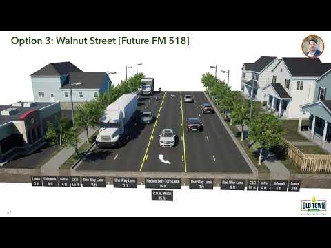
The study evaluated three long‑term alternatives against the 2045 no‑build baseline: a one‑way pair that would route eastbound traffic onto Walnut and westbound traffic onto Broadway/FM 518 between McLean and Barry Rose; an access‑management approach adding raised medians to limit left turns; and a six‑lane capacity widening east of Barry Rose to East Edgewood Drive.
Consultants modeled two variants of the one‑way pair: one that assumes the east segment remains four lanes and another that assumes that segment is widened to six lanes. The one‑way pair showed clear congestion relief within the paired segment; the six‑lane variant also improved operations east of Barry Rose. Access management fared best in modeled safety performance but did not materially reduce congestion. The six‑lane widening improved both safety and mobility where it is implemented but would not address bottlenecks in the Old Town segment unless combined with other measures.
The consultant team noted caveats in modeling one‑way pairs because national precedents are limited; analysts said a one‑way pair reduces intersection conflict points substantially but some of those safety benefits are not fully captured by the statistical models used. The team also noted non‑modeled benefits from widening — specifically faster emergency response times — and said all build alternatives include new sidewalks and sidepaths to improve pedestrian and bicycle access.
Public and council discussion
Councilmembers and commissioners pressed consultants on practical impacts: how businesses along Broadway and FM 518 would be accessed under a one‑way configuration, whether cut‑through traffic would increase on adjacent residential streets, and how emergency vehicle operations would be affected by raised medians. Saul said converting to a one‑way pair would likely require new signals and traffic diverters and would change how drivers reach businesses, requiring some motorists to travel to upstream intersections to return to a desired driveway. Jack Schick of Alliance Transportation Group, who presented additional Old Town alternatives later in the meeting, said alternatives that shift traffic from FM 518 to Walnut may increase delay at the Walnut/SH‑35 intersection unless SH‑35 receives complementary capacity upgrades.
Several elected officials also questioned outreach levels and cost information for specific improvements; consultants said cost estimates and detailed right‑of‑way impacts would be developed in later design phases. The team noted the city has already used study findings to pursue a Transportation Alternatives Program (TAP) grant application to fill sidewalk gaps.
Decisions and next steps
No policy decision was made at the workshop. Consultants recommended further study and public outreach, additional traffic modeling for Old Town alternatives, and detailed design work to assess right‑of‑way needs and construction costs. City staff confirmed additional analyses will be required before council or the commission would commit to a specific long‑term configuration.
Ending: The presentation framed the options and tradeoffs facing Pearland as growth continues. Staff and consultants said the next steps are targeted modeling, design‑level cost estimates and more public engagement before any formal decisions about the corridor are made.