Get Full Government Meeting Transcripts, Videos, & Alerts Forever!
Get email alerts on the Trails topic
No spam. Unsubscribe anytime.
Santa Clara staff outline Hetch Hetchy corridor trail plan; major obstacles include SFPUC right-of-way and a railroad overcrossing
Summary
Santa Clara Public Works presented a Creek Trail Network master-plan study for the Hetch Hetchy corridor in a virtual public meeting, saying the corridor could connect Sunnyvale and Mountain View through Santa Clara to the Guadalupe River but would require negotiations with the San Francisco Public Utilities Commission and major engineering work.
Santa Clara Public Works presented a Creek Trail Network master-plan study for the Hetch Hetchy corridor in a virtual public meeting, saying the corridor could connect Sunnyvale and Mountain View through Santa Clara to the Guadalupe River but would require negotiations with the San Francisco Public Utilities Commission and major engineering work.
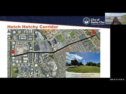
"The vast majority of the land is owned by the San Francisco Public Utilities Commission. It's approximately an 80 foot wide right of way," said Jonna Sokal, principal trail planner for the Creek Trail Network expansion master plan, summarizing the project ownership and constraints. Sokal said the right-of-way carries major drinking-water pipelines from Yosemite into Santa Clara Valley and limits what can be built atop it.
The presentation described a roughly east–west route from Calabasas Creek through the Great America/Levi's Stadium area, across Union Pacific tracks near Lafayette and into Lick Mill Park, Ulistac Natural Area and the Guadalupe River. The corridor crosses three creeks and would likely need three earthen levees, a pedestrian/bicycle bridge over San Tomas Aquino Creek and a substantial overcrossing to span Lafayette and the railroad.
Why it matters: the proposed trail would create an off-street commuter and recreational connection to commuter rail and light rail, parks, and major employment centers north of U.S. 101. Consultants and staff said it would close gaps in the Santa Clara Valley trail network and provide bicycle and pedestrian access to Mission College, the Guadalupe River Trail and other corridors.
Key technical and permitting constraints
Sokal said the corridor is a mix of public parks, private redevelopment sites and the SFPUC right-of-way. Because the alignment runs where the utility needs space to stage repairs and maintain buried pipelines, the agency now is more cautious about permitting long linear public facilities on its land and, in many cases, charges a recurring fee for use. Valley Water also owns and maintains the creeks the trail would cross and has issued guidance about placing trails in its channels.
Project staff identified several technical constraints that would affect cost and schedule: the SFPUC right-of-way width and maintenance needs; construction limits near buried pipelines; the need for an engineered overcrossing of the railroad; creek crossings and associated levee or ramp design; event- and security-related issues at the stadium/Great America area; and property dedications or redevelopment agreements for segments that fall outside the right-of-way.
Cost and timing
Sokal said preliminary, order-of-magnitude costs for each corridor are "in the tens of millions of dollars," and that the city has not yet finalized detailed estimates. She said the master plan is intended to identify priorities, refined alignments and possible funding approaches; the consultant team expects to complete the draft master plan for public review in 2026.
On schedule, staff said even with a green light, detailed design, environmental review, permitting and construction mean "you might not see a trail in the ground for 4 to 5 years," and that completing long, contiguous segments could take decades as existing right-of-way, redevelopment timing and funding allow.
Public questions and alternatives discussed
In the meeting's question-and-answer session, residents raised several implementation questions: how much of the alignment would sit on SFPUC land (percentage and mileage were "not specified" and staff said they would provide numbers later), whether SFPUC would agree to allow trail construction (Sokal said the agency has historically allowed access but is now more cautious and that any alignment would be the result of negotiation), and whether an at-grade railroad crossing was feasible (staff said it was not under consideration).
Residents proposed interim or alternative routes, including using the existing Agnew crossing or routing around the rail corridor parallel to the tracks. Sokal said longitudinal trail placement adjacent to an active rail corridor is typically limited by security and right-of-way constraints and would require detailed feasibility study. She also said the project team had not yet assessed connections through the Related Companies redevelopment site near the Guadalupe River but would review whether those plans could provide a lower-cost bridge or routing option.
Survey and design preferences
City staff reported results from a May survey of about 90 respondents across the three corridors. More than half of those respondents said they would use the studied trails on a daily or weekly basis. When asked about amenities, the top preferences were trees, comfort stations, water refill stations, wayfinding signs and enhancements to wildlife habitat.
Next steps
Staff said they will continue outreach, present refined alignments in the fall, circulate a draft master plan for winter public comment, and ultimately seek City Council direction and potential funding options. The presentation noted an upcoming Calabasas Creek corridor meeting next week and asked residents to sign up on the project website for updates (santaclaraca.gov/creektrailplan).
At the close of the session, Sokal reiterated that the corridor presents significant opportunity but also substantial negotiation, engineering and funding challenges before trail segments could be built.