Get Full Government Meeting Transcripts, Videos, & Alerts Forever!
Get email alerts on the Trail Planning topic
No spam. Unsubscribe anytime.
Santa Clara reviews Saratoga Creek segment of Creek Trail master plan; tree loss and habitat mitigation drive feasibility questions
Summary
City of Santa Clara staff and consultants presented feasibility findings for the Saratoga Creek segment of the Creek Trail master plan, identifying two potential underpasses at Homestead Road and Kiley Boulevard, a pedestrian bridge at Stevenson and large habitat and property constraints that limit continuous creekside trail development.
City of Santa Clara staff and the project's consultant on Wednesday presented feasibility findings for the Saratoga Creek segment of a larger Creek Trail Network master plan, describing two potential underpasses, one pedestrian bridge and extensive environmental and property constraints that will shape whether and where an off‑street trail can be built.
Ralph Garcia, senior civil engineer and project manager for the City of Santa Clara Public Works Department, opened the presentation and said the meeting recording and project materials would be posted on the project web page. "This meeting will be recorded and posted online on the project web page at santaclaraca.gov/creektrailplan," Garcia said.
The consultant team led by Jana Sokal said the segment has a mix of areas with enough width to support a Class 1, off‑street, 10‑foot‑wide paved trail with 2‑foot gravel shoulders (14 feet total) and long stretches where there is effectively no top‑of‑bank available to build creekside trail. The team identified Homestead Road and Kiley Boulevard as locations where existing bridge geometry and channel clearances could allow underpasses; Stevenson was shown as a location for a pedestrian bridge. The presentation also identified five potential at‑grade crossings.
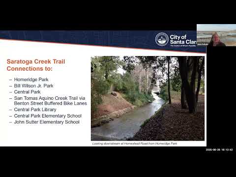
Why it matters: the creek corridor links parks, schools and the San Tomas Aquino Creek Trail and—if feasible—would improve walking and bicycling access to Central Park, the Central Park Library and nearby elementary schools. At the same time, much of the corridor is a regulated vegetation preserve under Valley Water ownership and contains wetlands and federally protected waters, which multiplies permitting and mitigation requirements and raises construction impacts.
The consultant and staff reviewed physical constraints that determine feasibility. In the corridor upstream from Benton Street, some reaches are wide enough for a trail, but many sections back up immediately to private yards built in the 1950s–1970s. The team said the channel was widened during flood control work in the late 1980s/early 1990s, which removed vegetation and created a Valley Water vegetation preserve that extends from the confluence with the San Tomas Aquino Creek upstream to Prune Ridge. That preserve includes riparian canopy and wetland habitat that regulators protect.
The presentation quantified likely impacts in one reach: from Home Ridge to Central Park, the initial estimate identified removal of about 94 trees to create the off‑street trail and underpasses; the consultants estimated that replacing those trees in mitigation could require planting "300-plus" trees because required mitigation ratios and species‑specific rules apply. Jana Sokal said that, because the corridor is a vegetation preserve, mitigation would need to be carefully located and might not be allowed to offset wetland impacts off‑site: "You might get permission to put some of them elsewhere, but you would not secure regulatory permits to try and put wetlands or impacts to creek waters elsewhere," Sokal said.
The Homestead and Kiley underpass concepts would require removing concrete channel lining and/or laying back channel walls to make room for a 10‑foot trail at low elevation; both underpasses would be expected to flood during winter storms, the team said. Where the channel is a box culvert or the bridge structure lacks clearance, the team said underpasses are not feasible. In several places, the roadway cross‑section could accommodate crossing improvements but there is no land on either side to land ramped underpasses.
Where creekside trail is infeasible, the master plan shows on‑street connections and short surface bike routes. The presentation highlighted a short connection at Benton Street that would link Saratoga Creek users to buffered bike lanes on Benton and from there to the San Tomas Aquino Creek Trail via San Tomas Expressway. The consultant said this "creek‑to‑creek" connection is one of the plan’s clear benefits if right‑of‑way and design changes on Benton proceed.
Staff clarified project status and schedule. Garcia and other staff said the master plan itself is funded and is scheduled to be returned to the Parks & Recreation Commission, the Pedestrian & Bicycle Advisory Committee (BPAC) and ultimately City Council next year for direction. Construction funding has not been secured. "The master plan is funded," Garcia said, "but the city is exploring these along with residents as a concept as to whether they should move forward." The team described two July meetings to introduce the Hetch Hetchy and Calabasas corridors and said additional outreach and a draft master plan will follow this summer.
Community input in the meeting focused on tree removal, trail alignment choices and crossings. Written comments read by staff urged use of rectangular rapid flashing beacons at some crossings and asked whether a narrow unpaved walking path could be used where full trail width is impossible; the consultant replied that in many places "there's maybe not as much as 2 feet available," and that a continuous path alongside the channel would not be safe or feasible. Members of the public also asked whether e‑bikes would be permitted; Garcia said current policy allows e‑bikes and that the posted speed limit for trails is 15 miles per hour.
Project constraints cited by staff and the consultant included: Valley Water's updated stewardship policy (board‑approved in 2021), riparian habitat and listed species in the corridor, Army Corps and regional water quality jurisdiction over stream and wetland impacts, and California Department of Fish and Wildlife mitigation ratios for oak and other species. Those regulatory constraints, plus narrow private property buffers, make implementation time‑consuming and contingent on property redevelopment in at least one location (a private property on Forbes was identified as a redevelopment opportunity that could allow extension to Forbes).
The presentation closed by noting prior planning work for Saratoga Creek and adjacent jurisdictions; consultants said the group's review built on earlier plans and that longer regional connections (for example to Stevens Creek Boulevard) are separately scoped and would require additional projects and agency coordination. Staff encouraged interested residents to sign up on the project web page to receive updates and to participate in upcoming workshops.
No formal council action or votes took place at the virtual meeting; the session was a public outreach presentation and Q&A.
Ending: The consultant and staff emphasized that any implemented trail will likely be developed reach‑by‑reach over many years and subject to regulatory approvals, mitigation, property changes and funding decisions. "All trails take time to implement," the consultant said, citing the multidecade effort to build the San Tomas Aquino Creek Trail as an example of incremental progress.