Get Full Government Meeting Transcripts, Videos, & Alerts Forever!
Get email alerts on the Active Transportation topic
No spam. Unsubscribe anytime.
Santa Clara staff outline constraints, tree impacts for Saratoga Creek trail segment
Summary
City staff and consultants presented a master-plan review for the proposed Saratoga Creek segment of the Creek Trail Network, identifying feasible upstream sections, two possible underpasses, expected tree removals and mitigation needs, and that the master plan is funded but construction is not.
City of Santa Clara project staff and the consultant team on Tuesday described feasibility limits and environmental trade-offs for the Saratoga Creek segment of the Creek Trail Network master plan, saying some upstream reaches could support a paved, off-street trail but large stretches will require on-street connections and that construction funding has not been secured.
"This meeting will be recorded and posted online on the project web page," said Ralph Garcia, senior civil engineer and project manager for the City of Santa Clara Public Works Department, opening the presentation. Consultant Jana Sokal summarized mapping, hydraulics and habitat constraints that shape where a trail could be built along the creek.
The consultants said the most feasible continuous creekside trail would run roughly from Forbes to Benton streets, with two potential underpasses at Homestead Road and Kiley Boulevard, one pedestrian bridge near Stevenson and five possible at‑grade crossings. "At Homestead and Kiley the concrete lining could be removed and laid back to create space for a 10‑foot wide trail at the bottom of the channel," Sokal said, but added those underpasses would flood during winter storm events.
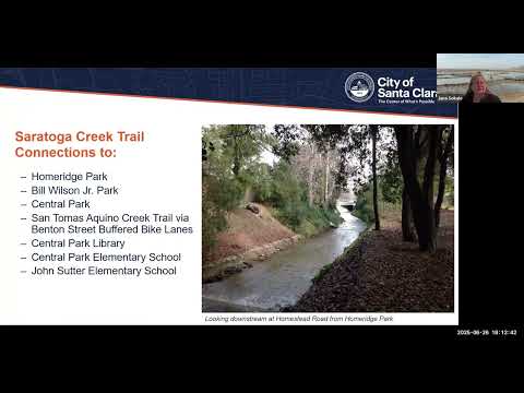
Why it matters: Saratoga Creek connects several city parks and neighborhood destinations — Home Ridge Park, Bill Wilson Junior Park, Central Park and the Central Park Library — and could provide a walkable, bikeable link to the existing San Tomas Aquino Creek Trail via buffered bike lanes on Benton Street. But the corridor is constrained by Valley Water vegetation preserves, private backyards built to the creek edge, and flood‑control works that reduced available top‑of‑bank width.
What was presented: The consultant team walked through a reach‑by‑reach map from Forbes downstream to Monroe Street. They flagged long stretches where there is "no land available" for a creekside trail, shown in red on their maps. Areas colored yellow or green indicate sections with potential width to support a trail. For the reach from Home Ridge Park into Central Park, the team estimated 94 trees would need to be removed to construct a 10‑foot trail with two‑foot gravel shoulders (about a 14‑foot corridor). Because the creek is already a vegetation preserve, Sokal said mitigation could require planting "300 plus" replacement trees to meet regulatory expectations.
Environmental and regulatory context: Sokal noted Saratoga Creek contains wetland habitat and federally protected waters in parts of the corridor, and that work in the channel would require coordination with the U.S. Army Corps of Engineers, the regional water quality control board and Valley Water. She also cited a Valley Water policy approved by its board in 2021 that makes the agency more cautious about balancing public access with riparian stewardship. "It's a complex question," Sokal said of tree mitigation locations, noting regulators generally want replacement plantings close to the creek and that different species (for example, oak) are subject to different mitigation ratios under California Department of Fish and Wildlife guidance.
Project design and user amenities: The team said survey respondents ranked Calabasas Creek highest among the three corridors under study and Saratoga Creek second; many respondents reported they would use Saratoga Creek weekly or daily if a path were provided. Top amenities requested were trees, restrooms, wayfinding signage and water‑bottle filling stations. The consultant noted bike repair stations can be difficult to maintain because tools and pumps are sometimes stolen; parks department restrooms and bottle fillers are already present at some park interfaces.
Policy and funding status: Project staff said the master plan phase is funded but the city does not yet have construction funding. "This is the time to provide your feedback through the public workshops," Garcia said; staff said the draft master plan is scheduled to go to City Council next year, at which point council would provide direction on moving forward. A panelist also noted a Saratoga Creek trail segment had lost prior funding due to concerns about tree removal and mitigation.
Public questions and staff responses: During the public Q&A, staff answered questions about whether narrow unpaved walking trails could be used where space is tight — Sokal said many reaches literally have only two to three feet of space and are impractical for continuous walking paths without encroaching on private property or the stream channel. On the question of e‑bikes, Garcia said trail policy currently allows e‑bikes and that there is a 15‑mph speed limit on trails.
Next steps: The City will hold outreach in July on the Hetch Hetchy and Calabasas corridors, follow up with summer technical work and circulate a draft master plan for public comment, then return materials to advisory bodies and, later, City Council. Staff encouraged residents to sign up on the project web page for notices.
The presentation and meeting recording are posted on the City of Santa Clara Creek Trail Master Plan project page.