Get Full Government Meeting Transcripts, Videos, & Alerts Forever!
Get email alerts on the Active Transportation Bikeways topic
No spam. Unsubscribe anytime.
Santa Barbara unveils design updates for 3.1-mile Cliff Drive separated bikeway; parking and tree removals detailed
Summary
City staff presented updated designs for a 3.1-mile separated bikeway on Cliff Drive, showing new crossings, four traffic signals, a reduction of 46 on‑street parking spaces and proposed removal of 25 street trees, and outlined next steps including committee reviews and CEQA filings.
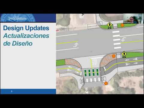
Santa Barbara City Public Works on Wednesday presented updated designs for a 3.1-mile, all-ages separated bikeway along Cliff Drive and described parking, tree and signal changes as the project moves toward final design and environmental review. Project planner Michelle Bedard said the project will convert the former State Highway 225-style roadway into a “neighborhood‑serving street” with a separated path for bicyclists, enhanced crosswalks and new landscaping.
The plan calls for a separated bikeway largely on the south side of Cliff Drive, 14 new crosswalks and four new traffic signals, including signals at the Santa Barbara City College West and East campus entrances and a new signal near the Mesa shopping center. Bedard said the project will complete a missing gap along the regional coastal route that links Ventura and Carpinteria through Santa Barbara to Goleta and UCSB.
City staff emphasized tradeoffs between parking and safety. The city’s parking inventory along Cliff Drive currently shows 79 on‑street spaces on the north side and 109 on the south side for a total of 188. Under the proposed design the south side would be reduced to 63 spaces and the corridor total would fall to 142, a net loss of 46 spaces. Bedard said staff conducted five daily counts at five times of day and observed a peak of 131 parked vehicles (noon Sunday) and a low of 73 (4 p.m. Sunday); the proposed 142 spaces exceed the observed peak demand.
The presentation also covered street trees. Staff reported 322 existing street trees in the public right of way; 25 trees have been identified for potential removal (23 in the public right of way and two on Santa Barbara City College property). Bedard said the removals will be reviewed first by the Street Tree Advisory Committee and later by the Parks and Recreation Commission, and that the project proposes about 70 new street trees elsewhere along the corridor.
Traffic operations and safety features drew multiple questions during the webinar. Derek Bailey, principal traffic engineer, said signals would be coordinated and some pedestrian signals will include leading pedestrian intervals where appropriate; he estimated that measured speed limits after construction will likely fall from the existing 35 mph to “probably about 30, possibly even 25 in the commercial area.” Bailey said one existing northbound right‑turn lane at Loma Alta that has a history of collisions will be removed to reduce conflicts with cyclists and pedestrians.
Staff said several design variations will be available for review at an in‑person open house the following evening at Monroe Elementary School, where full corridor strip maps and more detailed renderings will be available. The project remains in environmental review; Bedard said the city will file California Environmental Quality Act (CEQA) documentation and that the team is evaluating whether parts of the project qualify for a coastal exemption. Bedard said the schedule anticipates construction readying in 2027 under current grant funding and an approximate two‑year construction window, with completion around 2029 if the schedule holds.
Next formal steps include review by the Street Tree Advisory Committee (meeting noted as the next day), the Parks and Recreation Commission (June 25), a Transportation and Circulation Commission update later in the month and a tentative City Council update in July where the environmental determination will be reported. Bedard repeated the project web address (santabarbaraca.gov/cliffdrive) and encouraged residents to attend the open house and upcoming commission meetings.
The webinar included detailed staff responses on parking counts, bike facility crossovers in the commercial corridor, bus stop locations near City College, utility undergrounding (no firm timeline provided), and design choices where right‑of‑way limits constrain two‑wheeled roadway options (for example, near Arroyo Burro). Staff repeatedly noted the project’s objective of providing Safe Routes to Schools connections to Monroe, Washington and McKinley elementary schools and the City College campus. The presentation emphasized separation among pedestrians, cyclists and vehicles in keeping with the city’s Vision Zero goal to reduce fatalities and serious injuries.
Public commenters raised concerns about parking loss, tree removals, the proximity of new signals, and enforcement of e-bike and motorized device rules; staff noted enforcement is a separate, ongoing program and said signal and pavement decisions aim to reduce vehicle speeds and conflict points. Bedard and other staff members invited written follow‑up questions and said they would post tree exhibits and the updated renderings on the project web page following the webinar.
No formal council or commission votes were taken during the webinar; staff described planned administrative reviews and the upcoming public meetings where formal actions (for example, tree removal permit recommendations or environmental findings) will be considered.