Porterville staff outline parcel map options, SB 9 implications for 631 East Henderson

3635365 · June 2, 2025

Loading...

AI-Generated Content: All content on this page was generated by AI to highlight key points from the meeting. For complete details and context, we recommend watching the full video. so we can fix them.

Summary

City staff reviewed a proposal to divide a 4.77-acre property at 631 East Henderson into two lots, discussed SB 9 as a faster option that could waive some local standards, and flagged fire-access and utility requirements and related fees; staff will issue formal comments in about two weeks.

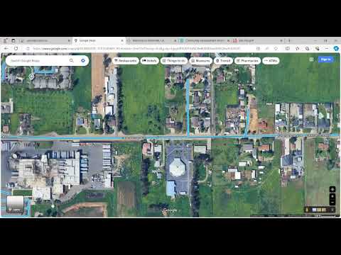
The Porterville Project Review Committee on Oct. 16 reviewed a preliminary parcel map application (PRC-2024-030) to divide a 4.77-acre property at 631 East Henderson into two lots and discussed two main pathways for approval: the standard tentative/final parcel map process and the SB 9 ministerial process under state law.

City staff said the parcel split is being pursued in part to allow mortgage financing separate from the church that occupies part of the property. Oscar Cepeda, chairperson of the Project Review Committee and associate planner, said, "the applicant is proposing a preliminary residential parcel map to divide the existing parcel of 4.77 acres into 2 lots." Staff noted that an applicant seeking a tentative parcel map must submit a map prepared by a registered civil engineer or licensed land surveyor and pay several fees, and that a final map and additional fees are required to record the division.

The discussion mattered because the choice of process affects public notice, which development standards apply and what improvements the city can require. Under the standard tentative-map route, the Parcel Map Committee would hold a public hearing with mailed notices to adjacent owners within 300 feet and newspaper publication; a tentative map approval typically has a two-year life unless extended. Under the SB 9 route, staff said the process could be ministerial if the split meets the state statute's requirements, which can remove the public-hearing step and allow relief from some local development standards when the government-code conditions are met.

Most important details

- Proposal: subdivide a 4.77-acre lot at 631 East Henderson into two residential parcels; applicant indicated intent to place a new roughly 1,600-square-foot single-family home where a prior dwelling stood.

- Fees and filings discussed: staff cited a tentative parcel map fee of $1,500; a city document-preparation charge of $79; a county filing fee of $58 payable to the Tulare County Clerk; and a final map fee ($955) to record the division. (Some transcript figures were unclear; the $79 city charge and the $58 county fee were stated during the meeting.)

- Public notice and timing: the tentative-map route requires public notices to adjacent property owners within 300 feet and newspaper publication and may add several weeks to processing; staff said an SB 9 ministerial route could remove the public-notice/hearing step and shorten timing, though staff will confirm applicability.

- SB 9 residency affidavit: staff explained SB 9 requires an applicant to sign and record an affidavit declaring the applicant intends to reside on one of the two resulting parcels for at least three years; staff said the statute permits some flexibility in order of operations and who signs the affidavit (the affidavit states intent to reside rather than immediately proving occupancy).

- Fire access and life-safety measures: Clayton Dignam, fire marshal, summarized fire-protection constraints if the new home is built, including proximity to hydrants and access geometry. Dignam said the building would need to be within about 400 feet of a hydrant and described the department's measurement standard for hose-lay distances (50 feet measured to the center of the rear-most wall); he also said a 20-foot-wide fire lane is required where shown and that a turnaround is needed if an access exceeds 50 feet.

- Utilities and public works comments: Javier Sanchez, engineering director, and David Cain, water utility superintendent, addressed utilities. Staff confirmed there are separate refuse accounts for the two parcels. Sanchez said that if the SB 9 route applies, the city generally cannot require additional on-site improvements as a condition of the ministerial parcel split, but separate utilities will be required at building permit. Cain noted the property currently uses private wells in places and that, when the residential lot is developed, water and sewer services in the street can be tapped; he also said on-site verification would be needed to determine whether a backflow-prevention device is required (Cain: "we would probably have to be on-site to verify ... there's a 10 foot separation gap in the plumbing to not have that backflow device included").

- Technical-lot standards: staff reiterated local lot-configuration limits such as a commonly applied 2.5:1 depth-to-width ratio and that, based on the proposed width, they used a 310-foot maximum as a working limit; they said the parcel-map review would evaluate minimum standards but that SB 9 could alter which development standards apply if the statute's conditions are met.

Next steps and direction

City staff said they will research SB 9 applicability for this property and include findings and department comments in a formal comment letter to the applicant in about two weeks. Staff advised the applicant to have a land surveyor or civil engineer prepare the tentative map; once submitted the map will be checked for technical correctness and processed by the Parcel Map Committee. The applicant and staff discussed the order of operations for building and financing — staff noted there are several permitted permutations (affidavit, then funding, then final map or vice versa) but emphasized the affidavit requirement for SB 9.

What was not decided

No formal action or vote was taken during the Project Review Committee meeting. Staff and the applicant discussed options and constraints but did not file or approve a tentative or final map at the session.

Meeting context

The discussion was limited to one agenda item (PRC-2024-030) and generated technical questions from multiple city departments (planning, fire, building, engineering, water). Staff will return written comments to the applicant; the Parcel Map Committee will review any submitted tentative map and must apply applicable state and local rules when making a determination.