Get Full Government Meeting Transcripts, Videos, & Alerts Forever!
Santa Clara launches public outreach for Creek Trail Network master plan, highlights ownership and flood constraints
Summary
Santa Clara Public Works staff and project consultants opened the first community meeting for the Creek Trail Network expansion master plan, outlining conceptual routes and asking the public for input on design choices and tradeoffs.
Santa Clara Public Works staff and project consultants opened the first community meeting for the Creek Trail Network expansion master plan, outlining conceptual routes and asking the public for input on design choices and tradeoffs. City project manager Ralph Garcia and principal planner consultant Jana Sokol presented corridor concepts and a project survey; Garcia said, “This meeting will be recorded and posted online on the project web page at santaclaraca.gov/creektrailplan.”
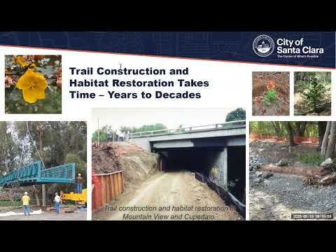
The master plan covers three study areas: Calabasas Creek, Saratoga Creek and the Hetch Hetchy corridor. The project team said the plan builds on a 2013 feasibility study and will move into detailed corridor‑level design after outreach. The team will hold additional corridor meetings, circulate a draft plan for comment and then publish a final master plan; the project survey will remain open until June 22.
Why it matters: the corridors could create continuous off‑street routes connecting parks, colleges, businesses and existing regional trails (including the Guadalupe River Trail and the San Francisco Bay Trail). But planners stressed that most of the land in the studied corridors is not owned by the city and that building continuous grade‑separated trails will require partnerships, permitting and funding from multiple agencies and private landowners.
Corridor specifics and technical constraints - Calabasas Creek: The team identified more available space in lower reaches near El Camino and the bay and far tighter conditions upstream. Several highway and railroad crossings lack the vertical or lateral room for safe underpasses. The consultant said the Highway 101 crossing uses a box culvert with vertical walls and center supports and “we determined that that was not feasible” to…
Already have an account? Log in
Subscribe to keep reading
Unlock the rest of this article — and every article on Citizen Portal.
- Unlimited articles
- AI-powered breakdowns of topics, speakers, decisions, and budgets
- Instant alerts when your location has a new meeting
- Follow topics and more locations
- 1,000 AI Insights / month, plus AI Chat