Get Full Government Meeting Transcripts, Videos, & Alerts Forever!
Get email alerts on the Creek Trail Master Plan topic
No spam. Unsubscribe anytime.
Santa Clara launches public outreach for Creek Trail Network master plan, highlights ownership and flood constraints
Summary
Santa Clara Public Works staff and project consultants opened the first community meeting for the Creek Trail Network expansion master plan, outlining conceptual routes and asking the public for input on design choices and tradeoffs.
Santa Clara Public Works staff and project consultants opened the first community meeting for the Creek Trail Network expansion master plan, outlining conceptual routes and asking the public for input on design choices and tradeoffs. City project manager Ralph Garcia and principal planner consultant Jana Sokol presented corridor concepts and a project survey; Garcia said, “This meeting will be recorded and posted online on the project web page at santaclaraca.gov/creektrailplan.”
The master plan covers three study areas: Calabasas Creek, Saratoga Creek and the Hetch Hetchy corridor. The project team said the plan builds on a 2013 feasibility study and will move into detailed corridor‑level design after outreach. The team will hold additional corridor meetings, circulate a draft plan for comment and then publish a final master plan; the project survey will remain open until June 22.
Why it matters: the corridors could create continuous off‑street routes connecting parks, colleges, businesses and existing regional trails (including the Guadalupe River Trail and the San Francisco Bay Trail). But planners stressed that most of the land in the studied corridors is not owned by the city and that building continuous grade‑separated trails will require partnerships, permitting and funding from multiple agencies and private landowners.
Corridor specifics and technical constraints - Calabasas Creek: The team identified more available space in lower reaches near El Camino and the bay and far tighter conditions upstream. Several highway and railroad crossings lack the vertical or lateral room for safe underpasses. The consultant said the Highway 101 crossing uses a box culvert with vertical walls and center supports and “we determined that that was not feasible” to modify for a trail underpass; an overpass may be the only viable option in some locations. The team also noted downstream vulnerability to tidal influence and sea level rise and that Valley Water is considering habitat restoration projects that could affect downstream layouts.
- Hetch Hetchy corridor: The right‑of‑way is roughly 80 feet wide in places, which gives room for paved trail segments, but planners cautioned that no subsurface columns or supports can be installed in the SFPUC pipeline corridor. The project consultant said SFPUC now typically requires cities to enter a joint‑use agreement, may charge a fee and can require the city to dismantle trail improvements when pipeline work or emergency access is needed. Planners said pedestrian crossings of active railroad tracks (Union Pacific/Amtrak/Capitol Corridor, and possible future high‑speed rail) cannot be done at grade and would require complicated overcrossings or negotiated rail crossings.
- Saratoga Creek: Planners flagged large stretches constrained by narrow top‑of‑bank conditions and a vegetation preserve established after 1980s flood control work. Potential undercrossings at Homestead and Kiely would affect mature trees and habitats; where no top of bank exists, planner recommendations include on‑street alignments or selective at‑grade connections.
Common themes: hydrology and habitat Planners repeatedly emphasized hydraulic constraints: many creek crossings and underpasses are formed by box culverts or levees that cannot be regraded without changing flood conveyance. The team said trails cannot introduce flood impediments or reduce the design capacity for a 100‑year event. Habitat sensitivity also constrains alignment and design: Saratoga Creek and other corridors contain vegetation preserves and species the team aims to avoid disturbing. The consultant noted opportunities to create mitigation — for example, regreening concrete sections where feasible — but said mitigation and permitting add time and cost.
Public questions and concerns raised Meeting attendees and online participants focused on safety, crossings, maintenance, lighting, access and how the city will handle sections that flood or are closed for events. - Crossings: Residents asked whether at‑grade signals or gates could allow rail crossings at Lafayette; the consultant responded that rail agencies typically will not permit new at‑grade crossings and that rail crossings are usually allowed only after major negotiation or if a crossing elsewhere is removed. - Flooding and closures: Several speakers said they prefer having a trail even if it floods occasionally rather than losing the connection entirely. Planners agreed closures are sometimes unavoidable because the creeks are flood control facilities managed to pass peak flows. The team said they will examine on‑street detours and more resilient routing where feasible. - SFPUC and private ownership: Speakers asked how willing SFPUC (San Francisco Public Utilities Commission) is to permit trail use. The consultant said SFPUC has become more restrictive and may require fees and clearability to remove trail infrastructure for maintenance or emergencies; she advised coordinating with private owners adjacent to the right‑of‑way to avoid taking SFPUC land where possible. - Lighting and wildlife: Residents asked about nighttime lighting under overpasses. The consultant — who also noted a biology background — said lighting decisions must balance user safety and wildlife disturbance, and that continuous 24‑hour corridor lighting is generally discouraged; limited, timed or downcast lighting and bollards were offered as examples used elsewhere. - Existing trail conditions: Frequent users raised pavement degradation, narrow sections and crumbling edges on the San Tomas Aquino Creek Trail; staff said repaving and restriping work is planned and that targeted “tender loving care” (pavement repairs, signage, small capital improvements) could be pursued sooner than larger master‑plan projects.
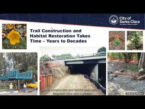
Implementation, partnerships and next steps City staff and the consultant stressed the project is a long‑term, phased effort that will depend on partner approvals (SFPUC, Valley Water, Caltrans, Caltrain, Union Pacific, Santa Clara County, private property owners), permitting from resource agencies and funding. The consultant explained that some sections have been built previously only after redevelopment or special agreements, and that some crossings will require costly overpasses or redevelopment negotiations (for example, near Levi’s Stadium/Great America and at Caltrain). The project team will continue corridor‑level analysis, hold follow‑up meetings, and circulate a draft plan for public review before finalizing the master plan.
Community outreach and how to comment Project staff asked residents to take the project survey (open until June 22) and said the project web page will host meeting materials and recordings. The project team encouraged written comments so staff can summarize them for the draft master plan.
Taper: Staff said design and construction will be phased, and many improvements would be built in reaches as partnerships, permits and funding allow. The plan sets priorities but does not guarantee immediate construction of continuous off‑street trails where land, hydraulics or ownership preclude it.