Get Full Government Meeting Transcripts, Videos, & Alerts Forever!
Get email alerts on the Zoning Text Amendment Beaver Dam topic
No spam. Unsubscribe anytime.
Planners advance Beaver Dam zoning text amendment; public hearing set for June
Summary
Buncombe County planning staff outlined proposed amendments to the Beaver Dam low‑density residential district to allow up to two dwelling units per lot, add new disturbance and impervious‑surface limits by lot size, and align Beaver Dam rules with county‑wide overlay standards. The board agreed to schedule a public hearing in June.
Buncombe County planning staff presented a work session on a proposed text amendment (ZPH2025‑00012) that would revise permitted uses and dimensional requirements for the Beaver Dam Low‑Density Residential district. The board agreed to schedule a public hearing for the amendment in June.
Staff described the proposed changes as part of an effort to modernize legacy Beaver Dam rules that predate county overlay and hillside standards. The proposal would allow up to two dwelling units per lot (attached or detached), permit alternative‑path hillside and conservation subdivision options that cluster development away from steep or environmentally sensitive areas, and add a new column of disturbed/impervious limits tied to lot size for parcels not in overlay protections.
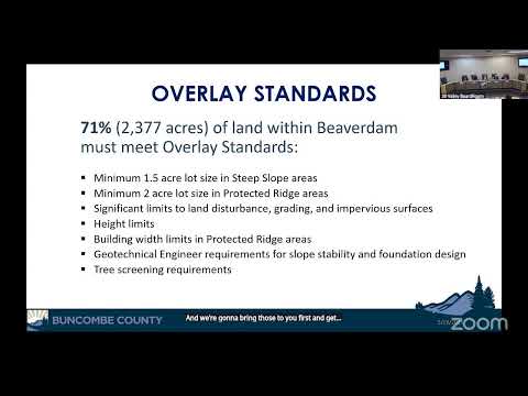
Staff presented data showing roughly 71 percent of the Beaver Dam district (about 2,300 acres) falls inside protective overlays (steep slope or protected ridge) and about 29 percent (roughly 1,000 acres) would be subject to the revised base standards. Under the draft dimensional table, minimum lot sizes outside sewer would be 30,000 square feet and 20,000 square feet when served by public MSD sewer. The table would also replace an existing acreage‑based disturbance limit with percentage limits by lot size: no percentage limit for lots under 0.5 acre; 80% disturbance / 60% impervious for 0.5–1 acre; 60% disturbance / 45% impervious for 1–4 acres; 40%/30% for 5–9 acres; and 30% disturbance / 20% impervious for lots of 10 acres or more. Staff said overlay areas retain stricter controls (for example, much lower disturbance and impervious caps and required geotechnical reports) and that overlay standards would continue to govern where applicable.
Staff emphasized the change would simplify standards (removing several Beaver Dam‑only footnotes and an average natural‑slope calculation previously used to determine lot standards) and would make the district consistent with other county zoning. “We are proposing to bring Beaver Dam into the same set of regulations that everybody else has,” a staff member explained during the presentation.
Board members asked clarifying questions about the overlay definition, how tree‑screening and height are measured in overlay areas, how septic systems are treated for disturbance calculations, and whether the proposed changes would make subdivision or development less costly and simpler in Beaver Dam. Staff said the overlay includes slope stability mapping from the North Carolina Geological Survey and that geotechnical reports and native‑species tree screening remain required in overlay areas. Staff also said the disturbance/impervious percentages were developed with input from county stormwater and erosion control staff and by testing typical development scenarios (for example, an 1,800‑square‑foot home with driveway and septic footprint) to ensure reasonable buildability while discouraging mass grading.
The board provided direction to schedule a public hearing for the text amendment at the June meeting; staff asked members to advise if they will be absent over the summer so hearings and subsequent items can be scheduled around member availability. No public comment was taken at the work session; staff said public notice and additional outreach will occur before the scheduled hearing.