Get Full Government Meeting Transcripts, Videos, & Alerts Forever!
Get email alerts on the Subdivision Morton 2025 17 topic
No spam. Unsubscribe anytime.
Porterville project review: staff outlines requirements for 20‑lot subdivision at 2211 Westmoreland Ave.
Summary
City staff reviewed a tentative subdivision map (PRC 2025‑17) proposing 20 single‑family lots on 4.89 acres at 2211 Westmoreland Avenue, discussed fees, design standards, potential CEQA exemption and options under SB 9 and ADU law; no formal action was taken.
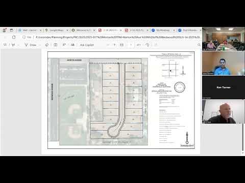
Porterville planning staff on Oct. 26 reviewed a tentative subdivision map, PRC 2025‑17 (Morton), proposing a 20‑lot residential subdivision on about 4.89 acres at 2211 Westmoreland Avenue in an RS‑2 zone with a Low‑Density Residential general plan designation.
The review centered on required fees and design standards, options for higher density through state laws, infrastructure requirements and environmental review. City staff indicated they will issue a written PRC comment letter and post the meeting recording online; no formal vote or permit decision occurred at the meeting.
Garrett Keller, planning technician and chair for the meeting, described the project and the materials under review. "The applicant's proposing a 20 lot residential subdivision on approximately 4.89 acres located at 2211 Westmoreland Avenue," Keller said. He told attendees the department would circulate a formal comment letter following the meeting.
Why it matters: the map determines lot lines, street layout and the range of uses that can be proposed once lots are created. Staff flagged issues that affect buildability and future permit costs, including whether the map will require a conditional use permit for driveway configurations and for lots that exceed standard depth or fall short of minimum width requirements.
City planner Jeff O'Neil said staff will evaluate whether the project qualifies for a categorical CEQA exemption for infill development. "If that's the case, then we would still need to have a little bit of enhanced ... assess whether the project could have significant effects in things like traffic, air quality, whether it serves, whether it could have habitat for species," O'Neil said. He added that desktop studies may suffice for some checks and that it is "likely that we can find it exempt," but emphasized the final determination will be made after staff review of a formal tentative subdivision map.
Staff and department comments and requirements
- Fees and filing: Keller said the subdivision map filing fee is $3,004 plus $39 per lot; the final map fee is $1,672; and a conditional use permit fee is $1,164. Keller also noted a possible Tulare County filing fee and that an environmental review fee or study could be required depending on staff's CEQA determination.
- Park requirement: For subdivisions under 50 lots, staff said a park in‑lieu fee may be paid instead of providing on‑site park land; the fee calculation follows the standards in "Resolution A 2025." Engineering staff reminded applicants that a new park fee adopted in January (effective February) assesses units by square footage and a separate park improvement fee.
- Zoning and density options: O'Neil and Keller explained the map will be processed as single‑family lots for RS‑2 zoning. They said duplexes cannot be approved on the tentative map; increased density similar to the applicant's alternate layout could be pursued later by using Senate Bill 9 (SB 9) provisions and accessory dwelling unit (ADU) laws through separate building permits and possible combinations of SB 9 and ADU allowances.
- Infrastructure and design: Engineering director Javier Sanchez said streets must be improved to city standards, water and sewer extended to the end of the cul‑de‑sac, and storm drainage in Morton is available for tie‑in. Sanchez added that street lights are required. He noted the cul‑de‑sac bulb shown on the map must be enlarged to a minimum 96‑foot diameter measured at the curb face to meet fire code standards.
- Fire and access: A city fire official advised the project must comply with applicable fire codes. For multifamily development, fire hydrant spacing would be a maximum of 300 feet; for single‑family dwellings that spacing can extend to 500 feet. The fire department also asked that all proposed roads meet city standards and have approved fire department access.
Applicant questions and staff guidance
The applicant (identified in the meeting as Ken) asked whether an environmental review would be required; Keller and O'Neil answered that an environmental review will occur but that staff will first assess whether the infill categorical exemption under CEQA applies. Staff also advised the applicant to include conditional use permit requests on the map submittal if they intend to seek relief for shared driveways, lots exceeding standard depth, or minimum width variances.
Staff suggested a minor lot configuration change: moving a narrow strip of land shown as part of Lot 8 to Lot 9 to create a more developable parcel. The applicant said a different map version shows a revised lot line that may address the concern.
Next steps and closure
Staff said they will publish the recording on the city's YouTube channel and send a written PRC comment letter with department comments and any required studies. No permit applications were decided at the meeting, and the PRC meeting concluded without formal action.
Ending note: Keller closed the session at 1:52 p.m., thanking participants and noting staff would follow up with the applicant about submittal details and next steps.