Get Full Government Meeting Transcripts, Videos, & Alerts Forever!
Lake County supervisors advance state fire-hazard maps; debate split-parcel rule
Summary
Lake County supervisors voted on June 10 to advance an ordinance that adopts updated fire hazard severity zone maps for local responsibility areas in the county’s unincorporated lands and scheduled final consideration for June 17.
Lake County supervisors voted on June 10 to advance an ordinance that adopts updated fire hazard severity zone maps for local responsibility areas in the county’s unincorporated lands and scheduled final consideration for June 17.
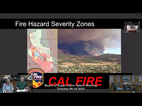
What the board considered is a state-produced update to Fire Hazard Severity Zones (FHSZ) covering Local Responsibility Areas (LRA). Maria Turner, Lake County community development director, told the board the Office of the State Fire Marshal required the update and that the draft maps were posted for a 90-day public comment period and were received by the county earlier this year. "What you have before you today is a proposed reading of a draft ordinance updating the fire hazard severity zones for our local responsibility areas," Turner said.
The maps and the ordinance are intended primarily to trigger building standards and hazard disclosures for new construction in the wildland-urban interface (WUI). Terry Logsdon, the county’s chief climate resiliency officer and tribal liaison, summarized how the Board of Forestry and Fire Protection and the State Fire Marshal produced the maps using fire history, vegetation, topography and wind modeling. He noted that map modeling for Lake County includes locally significant wind patterns…
Already have an account? Log in
Subscribe to keep reading
Unlock the rest of this article — and every article on Citizen Portal.
- Unlimited articles
- AI-powered breakdowns of topics, speakers, decisions, and budgets
- Instant alerts when your location has a new meeting
- Follow topics and more locations
- 1,000 AI Insights / month, plus AI Chat