Get email alerts on the Fire Safety topic
No spam. Unsubscribe anytime.
Lake County supervisors advance state fire-hazard maps; debate split-parcel rule
Summary
Lake County supervisors voted on June 10 to advance an ordinance that adopts updated fire hazard severity zone maps for local responsibility areas in the county’s unincorporated lands and scheduled final consideration for June 17.
Lake County supervisors voted on June 10 to advance an ordinance that adopts updated fire hazard severity zone maps for local responsibility areas in the county’s unincorporated lands and scheduled final consideration for June 17.
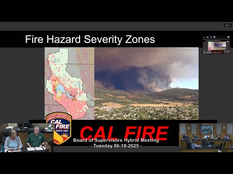
What the board considered is a state-produced update to Fire Hazard Severity Zones (FHSZ) covering Local Responsibility Areas (LRA). Maria Turner, Lake County community development director, told the board the Office of the State Fire Marshal required the update and that the draft maps were posted for a 90-day public comment period and were received by the county earlier this year. "What you have before you today is a proposed reading of a draft ordinance updating the fire hazard severity zones for our local responsibility areas," Turner said.
The maps and the ordinance are intended primarily to trigger building standards and hazard disclosures for new construction in the wildland-urban interface (WUI). Terry Logsdon, the county’s chief climate resiliency officer and tribal liaison, summarized how the Board of Forestry and Fire Protection and the State Fire Marshal produced the maps using fire history, vegetation, topography and wind modeling. He noted that map modeling for Lake County includes locally significant wind patterns known as quenocti winds and referenced CAL FIRE’s LNU unit materials. "They identify levels of fire hazard," Logsdon said, "and the zones are determined using the best available science and data."
Why it matters: adoption of the state maps affects which parcels require wildfire-resistant construction measures and which transactions require hazard disclosures. County and fire officials repeatedly described the update as an unfunded, state-driven requirement that local governments must adopt or make more stringent, but not less stringent.
Key points from the discussion
- Map purpose and limits: Logsdon and staff emphasized the maps are meant to identify hazard (topography, fuels, weather) rather than short-term risk, and that they are used to set minimum building requirements in the WUI. He told the board the maps use historical fire data from 1991–2020 and that the state maintains the official layers. The county will host submitted public comments on its website.
- Parcel-level precision: Several supervisors and public speakers pressed for clarity about how split parcels (lots containing two or more hazard zones) will be handled. Turner and CAL FIRE staff clarified the state’s guidance allows a local decision. Paul Duncan of CAL FIRE told the board that, for split lots, "they can develop on the lowest level, and then that is what that structure is considered." Turner's presentation said map resolution is coarse at roughly 30 meters (about 100 feet), which can create inconsistencies at parcel edges.
- Local discretion and legal requirements: Turner said local agencies may increase a designation above the state’s level but cannot reduce it. She read elements of the state guidance noting that if a jurisdiction raises a parcel to a very high designation it must make findings supported by substantial evidence under Government Code section 51182; raising to moderate or high is discretionary.
Public and agency input
- Patrick Reitz, fire chief of the Lakeport Fire Protection District, urged the board to adopt the maps as presented, calling them an "unfunded mandate" and warning against delaying county action. "I'm urging you just vote this in. Don't waste any time," Reitz said.
- Paul Duncan of CAL FIRE echoed that local work on defensible space and landscape mitigation is critical and said that, practically, many new structures will already be built to Chapter 7A ignition-resistant construction standards.
- Tom Lasik, a resident, asked what percentage of parcels are affected by split-zone issues; staff said that level of parcel-specific data was not published with the state maps.
Actions and next steps
- The board approved reading the ordinance in title only as amended (correcting a typographical year reference in section 4 to 2025) by a 4–1 vote. One supervisor recorded a no vote on that action.
- The board then moved the draft ordinance as amended to a subsequent board meeting for consideration and possible adoption on June 17 at 9:10 a.m.; that procedural motion passed 5–0. The state will maintain the adopted maps; the county may later adopt more stringent local rules during its ongoing updates to planning and safety elements.
What remains unresolved
- How the county will treat split parcels in practice (whether to require the highest zone across an entire parcel or allow structures sited wholly in the lower zone to follow that zone’s standards) was left as a local policy choice for the board and legal counsel.
- Officials and the public flagged concerns about map precision, the state map’s resolution of about 30 meters (~100 feet), and whether adjustments or local surveys will be recognized for insurance or permitting purposes.
Next procedural step: the draft ordinance as amended will return to the Board of Supervisors for consideration and possible final adoption on June 17 at 9:10 a.m.
AI generated
The text on this page is AI generated. Summaries, highlights, analysis, and video transcripts are all produced from the original source material.
AI can make mistakes, so if you spot one, and we will fix it for everyone.
Note: the source content is unaltered by us. Any content source we link to, be it a video, an audio recording, or a document, is presented exactly as its publisher released it. That publisher is usually a government body, sometimes an individual official or another organisation.