Get Full Government Meeting Transcripts, Videos, & Alerts Forever!
Get email alerts on the Land Use Development topic
No spam. Unsubscribe anytime.
Elkhorn Springs rezone and large subdivision pushed to June 19 after concerns about slopes, wildlife corridor and fiscal impacts
Summary
Commissioners continued a rezone and MDA application for the Elkhorn Springs subdivision — a proposed higher‑density project on about 15 acres — to June 19 after detailed discussion about cut/fill, slopes over 30%, wildlife corridor impacts and long‑term maintenance costs for proposed public amenities.
The Hideout Planning Commission continued consideration of the Elkhorn Springs rezone and related master development agreement to June 19 following an extensive staff briefing and questions from commissioners and community members.
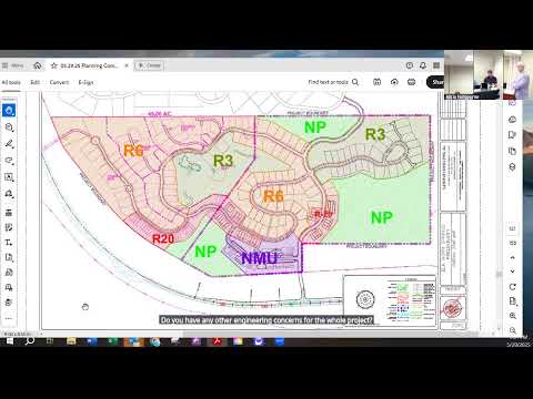
Staff summarized the proposal: the developer seeks higher‑density zoning on about 15 acres, with a mix of small‑lot single family, townhomes/stacked flats and a neighborhood mixed‑use node at the main entrance off State Route 248. The application proposes utilities, trails and about 15 acres of land the developer said it would donate for public use — land staff and several commissioners raised questions about whether donated lands should count toward the project’s required private open‑space percentage and about the long‑term cost to the town to operate any dedicated community facilities.
Why it matters The application requests multiple variances and MDA provisions that would allow development on slopes greater than 30 percent and cut/fill that exceeds the town’s 5‑foot standard. The project would also locate stormwater basins and other infrastructure near the drainage/wildlife corridor; commissioners and staff urged the developer to consider moving amenity areas out of the corridor to reduce conflicts with wildlife and to minimize landscape disturbance.
Key points from the staff presentation and public comment - Density and open space: Staff said the MDA requests would yield about 212 units (the developer later confirmed 212 units rather than earlier higher counts). Staff and the developer discussed the town code’s requirement for public amenity acreage — about 3 acres per 100 units — and whether the applicant’s proposed community center, indoor pickleball courts, plaza, Frisbee golf and parks meet or exceed that obligation. Staff estimated the code obligation at about 6.25 acres for the full project and requested a clear breakdown distinguishing private open space (required by code) from land proposed for donation to the town. - Sensitive lands and slopes: The concept plan shows areas with more than 10–15 feet of cut and fill and multiple sections with slopes above 30 percent. Staff said sections of the proposed development and some stormwater basins would currently sit within the town’s mapped wildlife/drainage corridor and recommended the developer move some features upslope to reduce impacts. - Fiscal analysis and amenities: Economic analysis presented by town consultant Rob Sand estimated annual gross revenues in a full‑build year around $317,000, with estimated municipal expenditures of roughly $198,000; the estimated net fiscal impact in the consultant’s model was about $119,000 annually. Staff cautioned that expenditures are difficult to project and that an added staff person to operate town‑owned facilities could swing the fiscal picture negative. The developer offered several mitigation items — a community center to donate or dedicate, funds for trail design and a proposed per‑lot maintenance payment (a per‑home contribution to help fund facility upkeep) — intended to offset maintenance costs if the town accepts dedicated facilities.
Public comment and applicant response Nearby residents questioned the viability of five lots close to SR‑248, raised safety concerns about tall retaining walls along some lots and asked about trail connections to adjacent neighborhoods. The developer’s representatives said they would consider reconfigurations — including moving some units and amenities — to reduce cut/fill in the wildlife corridor and to improve trail connections. The applicant confirmed offers of design funds and a proposed one‑time donation plus ongoing per‑lot support intended to underwrite facility maintenance.
Outcome and next steps The commission continued the Elkhorn Springs rezone and related MDA to June 19 to give staff and the applicant time to provide: (1) a clear open‑space calculation separating private open space from donated town land, (2) revised stormwater and retaining‑wall plans, (3) options that move proposed amenities out of the wildlife corridor where feasible, and (4) a refined fiscal and operations plan for any town‑owned facilities. Commissioners asked staff to circulate materials in advance so the commission can review changes before the June 19 hearing.