Get Full Government Meeting Transcripts, Videos, & Alerts Forever!
Get email alerts on the Coastal Resilience Corn Neck Road topic
No spam. Unsubscribe anytime.
New Shoreham presents Corn Neck Road vulnerability analysis; community backs nature‑based dune protection
Summary
Town officials and contractor GZA presented a vulnerability assessment for Corn Neck Road and outlined next steps including a master plan and conceptual designs; a public survey (138 responses) favored protecting dunes and maintaining beach access. No formal votes were taken.
Town of New Shoreham officials and the contractor GZA on Saturday presented a vulnerability assessment and near‑term planning steps for the Corn Neck Road Resilience Strategy and Dune Restoration Project, saying the effort is funded by the National Fish and Wildlife Federation and the Municipal Resiliency Program through the Rhode Island Infrastructure Bank.
The assessment, presented by Allison Ring, the town planner and GIS manager, concluded that Corn Neck Road and adjacent natural features are threatened by erosion, rising sea levels and storm waves and that protecting the roadway “through habitat preservation, dune and beach maintenance, and maintaining access” should guide near‑ and long‑term planning. Ring told attendees, “The Corn Neck Road Resilience Strategy and Dune Restoration Project, is funded through grant funding, through the National Fish and Wildlife Federation and, the grant through the Municipal Resiliency Program through Rhode Island Infrastructure Bank.”
Why it matters: Corn Neck Road provides vehicle and pedestrian access along the east and west sides of the road between Scotch Beach and the southern revetment. The analysis showed that higher water levels and more frequent storms will make today’s flooding events rarer in the short term but substantially more frequent by mid‑century and especially by 2070 under intermediate sea‑level‑rise scenarios; presenters emphasized planning that can be adapted as conditions change.
Key findings and evidence
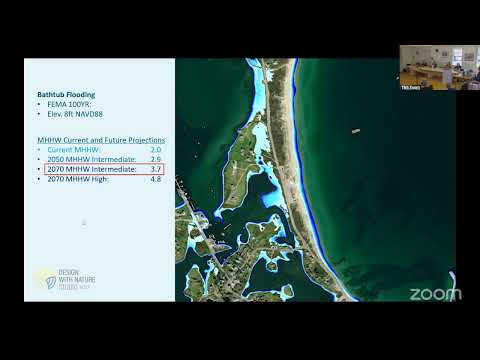
- Hazard drivers and recurrence: GZA’s coastal engineers reviewed met‑ocean data, wave hindcasts and wind records and reported that storms comparable to Hurricane Sandy align roughly with a 20‑year event while a major hurricane (Category 3+) is historically less frequent—presenters said on average a hurricane occurs about every 17 years and a Category‑3 or greater about every 50 years. Present‑day mean higher high water (MHHW) was described around elevation 2 (feet) with design flood elevations shown for 1‑, 2‑, 5‑, 20‑ and 100‑year recurrence intervals and comparable future elevations for 2050 and 2070.
- Lidar and aerial survey: The team used high‑resolution drone and lidar surveys (noted reference years include 2006, 2012 and 2022) to map current elevations and changes since Sandy. Present‑day lidar shows areas where dunes have naturally recovered seaward since 2006 and other locations—notably the seaward ends of several access paths—where the dune toe has not recovered to pre‑Sandy positions.
- Modeling: GZA used nearshore wave modeling (SWAN) and is coordinating with University of Rhode Island researchers on sediment‑transport modeling to understand currents and where sand moves alongshore. The presenters said model calibration on Sandy is in progress and is necessary to refine sediment transport predictions and to evaluate options such as beneficial reuse of dredged material.
- Local flooding and precipitation: Presenters noted that about 0.75 inch of rain in a day commonly triggers standing water in the Scotch Beach and Town Beach parking areas. They reported an observed increase in heavy‑rain days from roughly 1.5 events per month historically to an expected rate just over twice per month toward mid‑century.
Public input and priorities
GZA reported 138 survey responses. The top perceived climate threats were increased storm intensity, coastal erosion and rising sea levels; the top locations respondents wanted resilience work were the Town Beach Pavilion and parking area, maintaining beach access and the southern rock revetment. The project team summarized common public suggestions including limiting vehicle access in sensitive dune areas, improving public education about staying off dunes, and favoring natural, nature‑based solutions.
What the town and project team will do next
GZA said the vulnerability assessment will feed a master plan and then conceptual designs for nature‑based features such as dune stabilization, parking/lot grade adjustments, and improved paths. Presenters said the current grant funding covers planning and some short‑term implementation; they are preparing a report for the Coastal Resilience Committee and will make the materials available on the town website and at the library.
Allison Ring (town planner and GIS manager) and Mike Gardner (director of the GZA project team) described the immediate next step as producing a master plan and concept designs that can be advanced to engineering and, ultimately, construction as funding and permits allow. Gardner said the firm’s internal “Design with Nature” group will inform natural‑feature design choices.
Community questions and technical points
Residents and committee members asked about: narrowing or closing dune access paths (the presentation’s lidar comparisons showed closed paths have in places allowed dune recovery), options for accessible boardwalks or ramps across dunes, reusing dredged sand to nourish vulnerable areas, and whether soil or compaction changes (for instance after cable installation) have worsened parking‑lot flooding. Public Works Director Mike Shea confirmed the town places sand on the southern revetment annually and said last year’s Old Harbor dredging yielded “600 yards, 800 yards” placed on the revetment while the Town Beach parking lot typically receives much smaller annual additions. Shea said, “We do it almost annually,” when asked how often sand is added to the revetment.
Speakers at the meeting emphasized the need to coordinate sediment placement with modeling to avoid pushing sand away from targeted beaches; presenters said that is one purpose of the URI sediment‑transport work.
Limits and formal actions
No formal votes or ordinances were recorded at the meeting. Presenters and town staff described planning and funding steps but did not record any board motions. The meeting therefore produced direction and technical assignments (prepare the committee report, develop a master plan and concept designs, coordinate with URI and potential funders) rather than formal town decisions.
Next public steps and timeline
GZA and town staff said they will deliver the vulnerability assessment report to the Coastal Resilience Committee, post slides and summary materials for public review, and begin master‑planning work that will identify short‑term, adaptable measures and longer‑term options. The consultants said they expect to identify concept alternatives in the coming months and continue outreach; specific dates for milestone deliverables will be posted as the committee reviews the draft report.
Ending
Speakers thanked residents for participation and for the survey responses; the project team said it will return for further public outreach as the master plan and concept designs are developed.