Get Full Government Meeting Transcripts, Videos, & Alerts Forever!
Get email alerts on the Area Of Impact topic
No spam. Unsubscribe anytime.
McCall staff recommends data‑driven area‑of‑impact map; council leans to broader option
Summary
McCall Mayor Robert “Bob” [last name not specified] and the City Council spent a work session reviewing two draft boundaries for the city’s McCall area of impact after staff and outside consultants ran a 24‑factor GIS suitability model tied to the state statute adopted in 2024.
McCall Mayor Robert “Bob” [last name not specified] and the City Council spent a work session reviewing two draft boundaries for the city’s McCall area of impact after staff and outside consultants ran a 24‑factor GIS suitability model tied to the state statute adopted in 2024.
Michelle Grunewell, the city’s community and economic development director, opened the presentation and said, “the goal of this evening is really to prepare, for the May 5 meeting, which is a joint meeting between Valley County Board of Commissioners and the city council.” She told council members the team aimed to present a defensible proposal the city could take to the county.
The council heard from Logan Simpson consultants Megan Moore, senior planner, and Ben Ochsling, GIS analyst, and from Cushlin & Associates consultant Diane (last name not provided). Moore described the consultant team’s background and past McCall work; Ochsling explained the technical modeling. Moore said the analysis used existing plans, service boundaries and growth projections and that the model combined five statute categories — water and sewer, transportation, public services, anticipated growth and geographic factors — into parcel‑level suitability scores. Ochsling said the team ran 24 mapped criteria and “when we take all 24…and overlay them on top of each other and score them, we get this suitability map.”
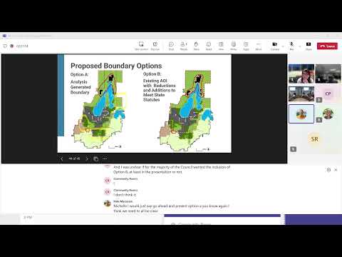
The consultants presented two options for the council: - Option A: an analysis‑generated boundary drawn from the weighted, parcel‑level suitability model. The boundary expands in several places from the current area of impact, notably south of the McCall airport, west toward larger parcels and in limited parcels north of Little Payette Lake. The model honored the state rule that a parcel cannot be bisected and that the maximum study area is roughly a two‑mile buffer from city limits. - Option B: a baseline that starts with the existing area of impact and only makes the statutory adjustments required by the 2024 law (for example, adding whole parcels that the two‑mile buffer otherwise would bisect and removing enclaves that do not meet the 2‑mile/parcel rules).
Grunewell and the consultants repeatedly described the work as a technical, data‑driven exercise. Moore said the red line shown in the presentation represented “what’s proposed based on this analysis,” and Ochsling described the darker green on the suitability map as the areas that “are more suitable for that area to be contained in the new areas of impact.” The team also showed water service boundaries (existing, 5‑year and 20‑year) and drive‑time modeling for fire and EMS as inputs.
Council members debated strategy and consequences. Council member Mike (last name not provided) urged a narrow approach for the initial presentation to the county, saying a simpler map might be easier for the county to approve. Council members Lyle, Julie and Colby all said they favored Option A; Julie said Option A was “data driven” and would allow the city to justify additions. Several council members emphasized the southern expansion (south of the airport and adjacent to River Ranch) as an area of particular interest and potential future growth pressure.
City attorney Bill Punkenny (spelled in the record as Bill Punkenny) and staff clarified legal and procedural points: the 2024 statute provides specific criteria for drawing an area of impact, the area may be revisited at least every five years, and establishing a boundary does not itself annex land. Diane and Grunewell recommended the city and county update a memorandum of understanding to clarify administration and processes for planning, permitting and code enforcement in the area of impact if a joint approach continues.
Council members coalesced around presenting the analysis to the county. Grunewell summarized the next steps: staff will revise materials using council feedback and prepare a meeting packet for the May 5 joint meeting with Valley County. Multiple council members expressed a desire to lead with the data‑driven Option A but to be prepared to discuss Option B and to negotiate specific parcels with the county. No formal council vote selecting a final boundary was recorded at this meeting.
Ending: Council members thanked staff and consultants and adjourned the special meeting. The city will present the draft boundary options and supporting analysis to the Valley County Board of Commissioners at the May 5 joint meeting and continue public and intergovernmental engagement through the city’s upcoming comprehensive‑plan processes.