Get Full Government Meeting Transcripts, Videos, & Alerts Forever!
Get email alerts on the Natural Resource Inventory topic
No spam. Unsubscribe anytime.
Grand Island advisory board hears update on Natural Resource Inventory, mapping and outreach plans
Summary
Consultants leading Grand Island's Natural Resource Inventory (NRI) reported progress on a web-based mapping tool, a 65-dataset inventory, plans for community interviews and a draft report timetable; the group discussed data hosting, sensitive-species protections and outreach steps toward the town's open-space planning process.
Robin Drake, the consultant leading the Natural Resource Inventory project, told the Grand Island Conservation Advisory Board on April 24 that the project team has compiled a large inventory of spatial data and is building a web-based mapping application for internal review and later public use.
"I'm Robin Drake with Robin Drake Consulting. I'm leading the NRI, natural resource inventory project," Drake said at the start of the update. She said the project team is assembling datasets, producing online and hard-copy maps and preparing a narrative report with recommendations.
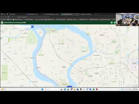
The NRI team described a technical deliverable and timeline: the consultants have gathered about 65 datasets so far and are creating analysis layers to support an eventual open-space plan. Jenny McGabro of Prospect Hill Consulting — the project's GIS mapping lead — demonstrated a preliminary web map that pulls together state, county and local layers and can, where possible, connect via web mapping services so some layers update automatically from their original sources.
"This will make a little bit more sense when Robin shares the narrative," McGabro said, and she walked board members through examples including hydrological systems, FEMA riparian zones, land-cover layers, invasive-species data and state natural-heritage records. She showed how metadata from the consultants' spreadsheet (source, update frequency, data-use limitations) is surfaced in the map application so users can identify the origin of each layer.
Why it matters: the board and consultants said the NRI and its mapping tool are intended to be a living reference that municipal staff, boards and community groups can use for grant writing, parks and recreation planning, open-space analysis and environmental review. Consultants emphasized that some datasets will remain internal during the project and that the group will decide which layers to publish publicly at the end of the NRI.
Key details and next steps
- Data and hosting: Drake said the consultants will migrate the assembled datasets to the town's servers so the town can host and maintain the NRI; she said she had contacted "Tom" from the town IT team to arrange that transfer.
- Sensitive data: the consultants warned some information (for example, precise locations of rare species noted in older, hand-compiled state park field books or natural-heritage occurrence data) may need to stay behind a firewall for municipal use only. Drake said the team will flag sensitive contributions during interviews and can keep restricted layers internal.
- Community interviews and imagery: the NRI will include a "community natural resources character map" based on interviews with local people who know special sites; Drake listed potential interviewees including Ken Robley and others. The team invited board members and residents to contribute geotagged photos and said it would create a shared folder for uploads.
- Branding and products: consultants showed logo and color concepts and discussed a consistent look for the written report, online map, hard-copy maps and outreach materials. Board members discussed preferences for colors and icons tied to local features.
- Project schedule: consultants aim to circulate a draft narrative before the board's July quarter meeting and to complete design and a final draft by September/October; the group agreed to set a follow-up meeting date by email.
Other topics raised in the meeting
Board members and consultants discussed related items that they expect to integrate with the NRI, including the town's Local Waterfront Revitalization Program (LWRP) materials, the parks-and-recreation master plan and the town's existing open-space index. The consultants noted nearby state projects (Beaver Island State Park improvements and invasive-species control work) and said those datasets will be referenced where relevant.
Tree inventory and operational notes
Board members reported the town is maintaining an internal tree inventory using TreeKeeper; a parks/highway staffer identified in the meeting as David Paul (highway department arborist) described routine pruning, treatments of ash trees and planned plantings in specific parks. Consultants said they would note those management programs and potential data feeds as part of the NRI.
Ending
Board members asked for a hands-on public workshop and suggested inviting representatives from town departments, planning and parks to a rollout so users understand which parts of the NRI they can use. Drake and McGabro said they would circulate revised branding options, propose several dates for the July quarterly meeting, and send the draft text and maps to the group for review before the next meeting.