Get Full Government Meeting Transcripts, Videos, & Alerts Forever!
Get email alerts on the Station Area Plan topic
No spam. Unsubscribe anytime.
Santa Clara task force reviews station-area plan alternatives; debate focuses on plazas, parks, boulevards and heights
Summary
Santa Clara’s Station Area Task Force on April 17 reviewed draft alternatives for the Santa Clara Station Area Specific Plan and gave direction on plazas, parks, retail nodes, boulevard designs and building heights ahead of a May community workshop.
Santa Clara’s Station Area Task Force on April 17 reviewed draft alternatives for the Santa Clara Station Area Specific Plan, as consultant WRT presented refined development concepts and placemaking strategies ahead of a community workshop.
WRT principal Jim (online) said the firm’s objectives were twofold: to show changes made in response to past task force comments and to present a coherent set of materials for public review. “This is a really exciting and important point in our process,” Jim said, asking the task force to endorse a range of options the consultant will carry to the May community meeting.
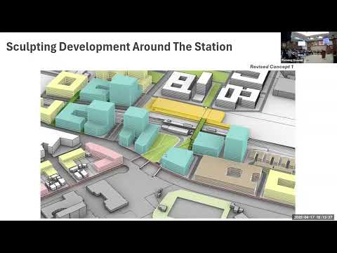
The draft alternatives refine three development concepts the task force saw previously: (1) a “maximize heights and density” option, (2) a more market-feasible residential-focused alternative, and (3) a strategic-growth mix that phases some parcels for longer-term change. WRT senior consultant Deeksha (online) summarized modifications made after prior task force feedback: move taller elements away from the historic train depot to preserve visibility, favor podium-plus-tower building types over continuous tall “walls,” step down building heights where new development abuts existing single-family neighborhoods, and test a linear park as a buffer between industrial uses and new residential areas.
Station plaza and retail activation
Consultants presented two station-plaza approaches: (a) a larger, development-opportunity parcel in front of the historic depot that could include buildings with activated ground-floor uses, or (b) a smaller civic plaza immediately in front of the depot emphasizing flexible, open space and light, configurable infrastructure for pop-up retail, events or food trucks. Deeksha said the team had explored moving a tower away from the depot and enlarging the public realm in front of the station.
On retail, the team proposed focusing required retail frontages in three “given” nodes: the downtown, the station node and Gateway Crossings. Jim described the rationale: “We’re focusing the retail in the downtown, in the station, not along Benton, but there’s a little corner retail moment along Benton,” noting the current market risk of “flooding” retail across the district.
Task force members and commenters tested that logic. Member Ganesh suggested adding a small retail cluster north of the station to serve a future residential/industrial area. A public commenter, James Fiso (commercial real estate broker), urged flexibility on large parcels (including the Costco site) and said higher legal height limits could be necessary to make redevelopment economically feasible. “In the Tasman East, there’s 4,500 units … out of those 10 applications, only 2 or 3 are going high rise,” Fiso said, and recommended allowing extra height on large parcels to increase land value and enable viable projects.
Parks and open space
WRT described two park approaches: a longer linear park that ties neighborhoods together and acts as a buffer between industrial and residential zones, and a sequence of smaller neighborhood pocket parks. Several task force members said they preferred a combination: a major linear park anchoring the district plus distributed smaller parks and programmed amenities (e.g., basketball courts, skate elements, spaces for concerts). Consultants noted the city parks master plan team is coordinating on programming needs and that specific park design would be set later by the city or project applicants.
Connectivity, underpass and station access
Task force members debated the primary pedestrian spine connecting downtown to the station: Franklin (a pedestrian-only paseo that passes through university property) versus Benton (a multimodal corridor with bike lanes and transit). Jim said both corridors should “work together” and play different roles — Franklin as a pedestrian paseo and Benton as a multimodal spine. Several participants emphasized that the success of Benton as a connector depends on an underpass or other crossing that links Benton and Brokaw; staff later confirmed public works received a $400,000 Metropolitan Transportation Commission (MTC) grant to begin a feasibility study for a Benton–Brokaw undercrossing.
Boulevards, bike lanes and bus rapid transit
WRT showed boulevard concepts for Coleman Avenue and El Camino Real that aim to slow traffic, add tree-lined medians, protected bike lanes and improved crossings. For Coleman, consultants proposed reducing through-lanes from three to two per direction with turn pockets while adding wider planting strips and protected bike lanes. On El Camino Real, the presentation referenced the city’s Central Bikeway plan and Grand Boulevard examples (Redwood City, Palo Alto) and showed concepts that would retain multi-lane vehicle capacity while adding protected bikeways and tree canopy.
Several members urged preserving future options for high-capacity transit: “At least have the infrastructure there to allow for [bus rapid transit] in the future,” one member said, arguing that once a corridor is narrowed, BRT becomes much harder to add. The task force also debated sidewalk and bike-lane widths; members cited existing standards (Franklin sidewalk roughly 20 feet; downtown/Benton sidewalks about 11 feet in prior plans) and recommended providing sufficient sidewalk capacity where many pedestrians are expected (e.g., near BART/Caltrain egress points).
Heights and FAA limits
Members revisited the playbook’s 15-story maximum and asked whether taller, well-placed towers could be appropriate north of the tracks where new development would not abut existing neighborhoods. WRT flagged earlier FAA/airport-based height constraints used in prior planning materials; in the meeting the consultants said most of the station-area parcels showed effective height limits in the 150–225 foot range on earlier maps and that the team would verify regulatory ceilings before recommending a preferred maximum. Several members recommended design controls (podium-and-tower limits, tower floorplate caps, stepbacks) to avoid “wall” effects while allowing flexibility for market-viable projects.
Next steps and public outreach
WRT asked the task force to endorse the presented range of alternatives for the May community workshop. Staff (Rebecca) said there will be no May regular task force meeting; instead a community workshop will be held via Zoom and consultants will present a preferred concept in June. Staff also confirmed the project will pursue a form-based code (grant-funded) after the preferred concept is selected and that environmental and transportation analyses would follow.
Votes at a glance
• Motion to excuse members Hashimoto, Mayor (name not specified in the record), and Stockwell: moved by Member Marinaro; second not specified; vote — unanimous, motion passed.
• Motion to approve consent calendar (minutes of Feb. 20, 2025): moved by Member Ganesh; second by the chair; vote — aye, motion passed.
Ending
Consultants said they will refine renderings, test boulevard and plaza cross-sections, verify FAA/airport height constraints, and return a recommended preferred alternative for the task force’s June meeting. Staff confirmed the MTC grant to study the Benton–Brokaw undercrossing will proceed to city council for acceptance and that WRT will provide materials for the public workshop.