Get AI Briefings, Transcripts & Alerts on Local & National Government Meetings — Forever.
Planning commission backs Tracy Hills Phase 1C: 289-lot subdivision, design standards approved
Summary
The Tracy Planning Commission voted to recommend City Council approval of the Tracy Hills Phase 1C specific plan amendment and vesting tentative map, clearing the way for 289 single-family lots and related design standards after hearing staff and developer presentations and public comment on evacuation, traffic and park timing.
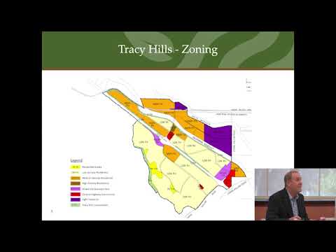
The City of Tracy Planning Commission voted to recommend that the City Council approve the Tracy Hills Phase 1C specific plan amendment and vesting tentative subdivision map, a proposal that would create 289 single-family lots, homeowners association parcels and public spaces on roughly 121.05 acres.
Staff planner Craig Hoffman told the commission the project is consistent with the site's general plan land-use designation of “residential medium” and would add a new Appendix F to the Tracy Hills Specific Plan with Phase 1C design standards. Hoffman said the project’s density would be about 6.45 dwelling units per gross acre, with lot sizes ranging from about 3,100 to 4,500 square feet.
The project team presented a phased buildout of Tracy Hills and described coordination with public safety and infrastructure partners. John Palmer, a Tracy Hills project manager, described the development as an integrated master-planned community with parks, recreation facilities and sidewalks. Mike Souza, another Tracy Hills project manager, said the development team has worked with the city to accelerate traffic improvements tied to occupancy triggers and noted the widen‑Corral Hollow/Ridgeline interchange work is expected to commence prior to the 2,600th occupied unit.
Why it matters: Phase 1C is the remaining vacant area south of I‑580 in the Tracy Hills site and will contribute to the city’s housing supply within the Tracy Hills specific plan area. Commissioners pressed staff and the developer on public‑safety evacuation access and the timing of planned road improvements; staff said the project includes conditions requiring coordination with police and fire on evacuation routes and temporary emergency access to Lammers Road.
Key facts and planning details - The vesting tentative subdivision map proposes 289 single‑family lots, associated HOA parcels and public spaces on about 121.05 acres (as stated in the staff report). - Project density stated by staff: approximately 6.45 dwelling units per gross acre. - Typical lot sizes in Phase 1C were described as roughly 3,100 to 4,500 square feet. - Staff recommended, and commissioners supported, two technical corrections to planning documents: correcting a CEQA cross‑reference to Phase 1C (not Phase 2) and fixing a finding that mistakenly used the word “industrial” instead of “residential.”
Public safety and traffic discussion Commissioners asked whether evacuation and emergency access had been revisited following recent regional wildfires. Hoffman said the project conditions require coordination with the police department and South County Fire on an evacuation plan and on construction setbacks and access standards. Mike Souza told the commission that evacuation routes and signage have been strengthened after recent fires; he said existing emergency access includes a gated gravel/rock road to Lammers Road that police and fire can open if needed.
On traffic, staff and the developer emphasized planned interchange and road improvements are tied to cumulative occupancy triggers. Hoffman and Souza said the Coral Hollow/Crow Hollow interchange and other choke points would be widened or improved ahead of or by the trigger tied to 2,600 occupied units; the developers and city reported securing federal grant funding to help build bridges and interchange improvements and forecast construction in the 2028 timeframe.
Public comment Tracy Hills homeowner and Regional Firewise Coordinator Erin Reel spoke in support of the project, saying she believed the EIRs were comprehensive and that the developer had cooperated with South County Fire and residents on fire‑safety measures.
Outcome The commission voted to recommend the City Council approve the specific plan amendment and vesting tentative map with the two corrections identified in staff’s presentation. The motion carried on a roll call vote with the commissioners present recorded as voting yes.
Next steps The Planning Commission’s recommendation will go to the City Council for final action. The project’s environmental analysis relies on prior environmental documents for the Tracy Hills specific plan; staff recommended no additional CEQA review for Phase 1C after correcting the cross‑reference noted above.