Fairview presents public draft of new development code; 30-day comment period opens
Loading...
Summary
Consultants from TPUDC and city planning staff presented a public draft of Fairview's new development (zoning) code, including new character districts, frontage and building standards, parking and sign rules, and draft zoning map. The draft will be posted online within 24 hours and the city will accept public comments for 30 days.
TPUDC consultants and Fairview planning staff on Tuesday presented a public draft of a new development code that would replace the city's existing zoning rules, change several zoning categories and map designations, and add detailed standards for building frontage, parking, open space and landscaping.
The public draft will be posted on the city's planning and codes webpage within 24 hours and a 30-day public comment period begins tomorrow and runs through Sept. 14, city planner Ethan Greer said. "It will be available within the next 24 hours on the city website as a PDF download," Greer said. Residents can submit comments by mail to City Hall at 7100 City Center Way, by visiting the Planning and Codes office at 7111 Bowie Lake Road, or by email to egreer@fairview-tn.org.
The draft, produced by TPUDC and revised after review by the city's development code committee, organizes rules into a set of "articles" that together form a character-based code aligned to Fairview's comprehensive plan, TPUDC presenter Anna said. "Zoning implements the vision of the comprehensive plan," Anna said during the presentation.
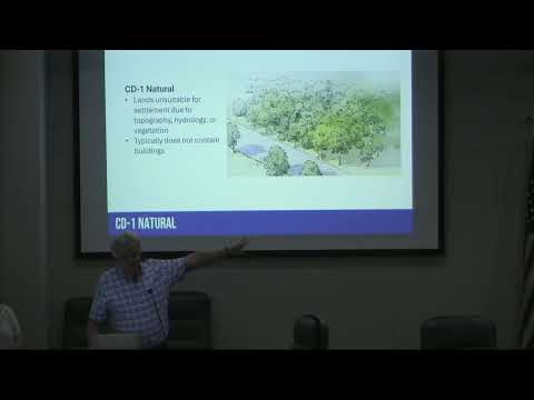
Why this matters: The draft replaces use- and density-based zoning with a character-driven structure of "Character Districts" (CDs) running from rural to the more urbanized corridor: CD1 (Natural), CD2 (Rural), CD2W (Woodlot, a district created specifically for Fairview's wooded lots), CD3L (Neighborhood large-lot), CD3 (Neighborhood), CD4 (Neighborhood Center), CD4C (Neighborhood Corridor), and CD CV (Civic). The draft also includes two overlay districts (Historic and Floodplain) and two industrial districts (Light and Heavy), and it maps each parcel in the city to one of these districts.
Key provisions and standards
- Districts and frontage: The code ties building form and "frontage types" (yard, porch, stoop, shopfront, et cetera) to each character district to regulate how developments look from the street and to promote walkability. Lot width and block perimeter are defined as elements that affect walkability and character.
- Building types and scales: The draft restricts the largest multi-family building type to what the consultants call "small multifamily" (six units per building was cited during Q&A), and sets maximum densities by district. TPUDC noted a revision in the public draft: CD4's allowed density was changed to 6 dwelling units per acre (total site-area calculation), while CD4C (the corridor district primarily mapped near I-40 and Highway 96) is set at 12 units per acre.
- Development-site rules: Larger development sites must meet walk-shed/density-mix standards. The code includes a pedestrian-shed (about a quarter-mile/15-minute walk radius) concept and requires a mix of building types and uses in larger CD4/CD4C developments to avoid single-use, large multifamily-only projects.
- Civic space: Any development site of 20 acres or more must allocate at least 5% but not more than 20% of gross acreage to "civic space" (defined types include greens, squares, plazas, playgrounds, sports fields, community gardens and pocket parks). For subdivisions with lots smaller than one acre, the draft requires a civic space within 800 feet of a residence. TPUDC emphasized civic space should be functional, not leftover stormwater areas.
- Parking, signs, utilities and infrastructure: Article 4 and related articles include a use table paired with parking requirements (including bicycle parking), dimensions for drive-through stacking and loading locations, sign metrics and objective sign standards, and requirements for underground utilities on new development.
- Tree preservation, slopes and environmental features: Tree preservation provisions, erosion control, and steep-slope protections are incorporated. TPUDC said tree preservation was among the most frequently-raised items during public outreach.
- Floodplain: The Floodplain Overlay is intended to track FEMA regulations for communities participating in the National Flood Insurance Program. TPUDC said the draft does not alter FEMA-designated flood elevations; any change to flood zones would likely come from FEMA or a separate flood study.
- Nonconformities and vested rights: The code includes a housekeeping article that addresses nonconforming uses and transition rules. Consultants and staff cited Tennessee state statute regarding vesting: projects with complete and compliant applications under the old code retain vested rights and may proceed under the prior rules.
Notable policy and mapping changes discussed
- Self-storage and industrial uses: City staff said the draft moves self-storage (indoor storage) from the Commercial General category into the Light Industrial category. Under the proposed map and use table, a commercial-to-storage conversion that would have been allowed under the current code would not be permitted in the same way under the draft.
- Scenic street/visual buffer concept: The draft includes a mechanism for a scenic street setback and buffer (a tool discussed as a way to preserve the wooded, "country-bridal" character of key approaches to town) though mapping and application of that tool are not yet finalized.
Process, timeline and public participation
- Availability and comments: Greer said the public draft and a draft zoning map will post to the planning and codes webpage and that a banner on the city website will direct residents to the documents. The city will accept mailed letters to City Hall, in-person visits to the planning office, or emailed comments to egreer@fairview-tn.org during the 30-day comment window.
- Next steps: Staff will compile comments after the Sept. 14 close of the comment period and send them to TPUDC. A planning commission work session to review the draft is scheduled Sept. 9 (during the public comment window), and commissioners also plan a work session in October. The planning commission is expected to take the draft up in October or November; if the commission approves it, the draft will move to the Board of Commissioners, which will hold a public hearing prior to second reading.
Questions raised at the meeting
Residents asked whether the draft affects pending building permits and were told it does not; vested projects under state statute remain unchanged. Attendees asked how the new map was created; consultants said the new map is a translation of existing zoning and current land uses, the city's adopted comprehensive/future land-use plan, and site visits made by TPUDC. Residents raised concerns about potential impacts on farms; TPUDC said agricultural uses appear in the use table and are permitted in the CD2 rural district and that state statutes related to agricultural protections were referenced.
Consultants and staff encouraged residents to review the full document (476 pages) and noted printed copies will be available at the planning and codes office. Staff said they will forward public comments to TPUDC for consideration in a final draft, which would then follow the planning commission and Board of Commissioners adoption process.

