Get Full Government Meeting Transcripts, Videos, & Alerts Forever!
Get email alerts on the Coastal Resilience topic
No spam. Unsubscribe anytime.
Block Island workshop outlines dune, parking and pathway options to protect Corn Neck Road
Summary
Block Island’s Coastal Resilience Committee and consultants presented conceptual designs Aug. 4 for protecting Corn Neck Road and adjacent dunes, parking and pedestrian pathways from storms and sea‑level rise.
Block Island’s Coastal Resilience Committee and consultants presented conceptual designs Aug. 4 for protecting Corn Neck Road and the adjacent dunes, parking areas and pedestrian pathways from storms and rising seas.
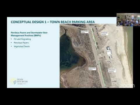
At the public workshop in New Shoreham, GZA consultants and committee chair Judy Gray outlined a menu of measures — permeable pavers, vegetated swales, dune restoration and access management — intended to reduce precipitation flooding in the Scotch Beach and Town Beach parking lots and to slow dune erosion along the corridor between Scotch Beach Road and the southern revetment.
The consultants summarized their vulnerability analysis and said the project’s “overall objective is to bolster the long term resilience of the barrier beach and salt marsh system while protecting the existing roadway,” a phrasing read aloud during the presentation by the consulting team. The committee emphasized the presentation would inform a later selection of design concepts.
Why it matters: consultants said sea-level rise will make storm-driven flooding and wave impacts more frequent and reach further inland. Using NOAA 2022 intermediate sea-level projections, they warned that a storm like Hurricane Sandy — about a 20-year event historically — could produce similar damages multiple times per decade by midcentury. That risk underlies the push for site-specific interventions along Corn Neck Road.
Key concepts presented
- Permeable-paver parking: Regrading the lots and installing permeable pavers over a crushed-stone reservoir to store runoff beneath the surface. Presenters said that, as designed in the concepts shown, permeable pavers combined with a vegetated swale could protect the lots up to a 100-year precipitation event, but would require periodic maintenance (sweeping/blading to remove sand) and a higher upfront cost. The consultants estimated permeable pavers would be on the order of three to four times the initial construction cost of a gravel alternative.
- Gravel/vegetated-swale alternative: A lower-cost alternative using porous gravel and larger vegetated stormwater swales that, according to the presentation, would protect to about a 25-year rain event but would consume more parking area because swales must be larger to store equivalent runoff.
- Dune-pathway management: Measures to reduce pedestrian- and vehicle-driven widening and cutting of dunes, including temporary path closures, revegetation, sand-trapping fencing, walkway mats and constructed boardwalks or dune walkovers. Consultants noted that gaps in dune elevation created by paths let waves reach lower, unvegetated areas and accelerate erosion.
- Hybrid, nature-based and offshore options: The team described living-shoreline and hybrid options (buried rock revetments with sand caps, cobble berms, reef-ball features offshore) as part of the broader toolbox, but said shore-parallel and in-water solutions require additional sediment-transport modeling and permitting review before they could be recommended.
Ownership, permitting and modeling constraints
Speakers emphasized limits on local authority for some structures. Judy Gray and others noted the existing southern revetment and some jetties are not solely town-owned and that state or federal agencies are responsible for those features; the consultants and community members specifically cited CRMC (Coastal Resources Management Council), FEMA, NOAA and the U.S. Army Corps of Engineers in the discussion of permitting and management. The presenters said they plan pre-application meetings with permitting agencies before advancing designs.
Annette (a University of Rhode Island researcher at the meeting) described a Sea Grant/NOAA-funded sediment-transport and circulation modeling effort for the Crescent Beach area aimed at testing whether offshore reef-like structures could attenuate waves without producing damaging redirecting currents. She cautioned that any design that traps sand in one location will typically cause erosion elsewhere unless the sand source is increased.
Funding and next steps
Committee members noted the project is being advanced with planning funds raised from the National Fish and Wildlife Federation and the Rhode Island Infrastructure Bank (about $650,000 for planning and a small pilot project, as stated at the meeting). The advisory committee said it will pursue external grants rather than recommending that the town pay the full upfront construction costs from local taxes.
The consultants asked for public input to refine concepts into a recommended design to move into further design and permitting. The workshop’s second half was structured as break‑out table sessions so residents could review maps, models and illustrations and provide feedback.
What was not decided
No formal decisions or votes were taken at the workshop; presenters framed the meeting as input-gathering. Several participants pressed for a prearranged plan if a major storm damages features such as the beach house near the dunes; attendees differed in opinion on removal versus relocation, and a community planning decision was identified as a future step rather than a meeting outcome.
Quotes
“ We are an advisory committee to the town,” Judy Gray said, describing the committee’s role in advancing projects and seeking funds rather than executing town budgets.
“ It’s complex … you could capture it there, but you might lose further north,” Annette, the URI researcher, said when describing tradeoffs for offshore reef concepts and sand redistribution.
Ending
Presenters closed by asking for feedback to guide a preferred concept and reiterated that additional modeling, permitting coordination with CRMC and state/federal agencies, and grant funding will determine which measures are feasible and when they can be built. The workshop shifted to table-based discussions to collect detailed community input on the concepts shown.