Get Full Government Meeting Transcripts, Videos, & Alerts Forever!
Get email alerts on the Land Use Map Housekeeping topic
No spam. Unsubscribe anytime.
Oro Valley staff seek to correct land-use map mismatches at four sites
Summary
Planning staff proposed 'housekeeping' changes to Oro Valley's 10-year land-use map at four sites to align the map with existing zoning and built development; working group generally supported the corrections and staff said changes will proceed through the public review process.
Oro Valley planning staff told a resident working group they will propose a set of "housekeeping" changes to the town's 10-year land-use map so the map matches existing zoning and development at four sites.
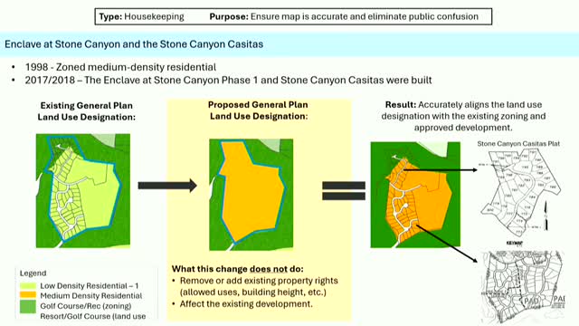
The proposed corrections focus on Stone Canyon (Enclave at Stone Canyon and Stone Canyon Casitas), the former Rancho Vistoso clubhouse area now in the Vistoso Trails Preserve, the Miller Ranch area (northwest corner of La Cañada and Tangerine by Lehman Academy), and a corner property at Lambert and La Cholla. Planning staff said the adjustments are intended to reduce public confusion where the land-use designation on the general plan does not match the zoning or what has already been built.
Melanie, a planning staff member, summarized the distinction between the general-plan land-use map and zoning: "the land use map, that is in the 10 year plan, and it really almost is a policy document, if you will. It provides guidance on the types of uses that the community wants to see in Oro Valley and where they are." She added that zoning grants property rights and that the map change is intended to reflect those rights where development already exists.
Staff described each site in turn. At Stone Canyon, subdivisions built under medium-density residential zoning currently show a low-density designation on the land-use map; staff proposed changing the land use to medium density to match zoning and what is built. For the Rancho Vistoso/Vistoso Highlands area, staff said the site is zoned high-density residential but listed as medium density on the map and proposed changing the general-plan designation to high density. At Miller Ranch, staff said a mix of uses has been approved — a school (Lehman Academy), a self-storage facility approved two years ago, and neighborhood commercial at the corner — and proposed updating the map to show those approved uses rather than an older Commerce Office Park label. At the Lambert/La Cholla corner staff proposed changing the land-use designation to reflect a commercial-2 zoning district and adjacent multifamily and single-family residential zoning.
Working-group members asked clarifying questions about how map corrections would affect property rights, conditional uses such as gas stations in C-2 zoning, and whether homeowners and HOAs would still be able to enforce private agreements. Staff reiterated that private HOA declarations are private contracts the town cannot enforce but that zoning and land-use map alignment can reduce public confusion.
There was no formal vote recorded at the meeting; staff reported that the working group generally indicated they had enough information and guidance to proceed with the proposed housekeeping changes. Melanie said the next steps would include sending draft changes to the Planning and Zoning Commission and Town Council and including them in required public outreach and the voter materials when appropriate.
The proposed corrections are advisory at this stage and will proceed through the town's standard public-notice, commission and council review processes before any formal change is adopted.