Get Full Government Meeting Transcripts, Videos, & Alerts Forever!
Get email alerts on the Land Use Access topic
No spam. Unsubscribe anytime.
Albemarle authority delays decision on shared driveway over conservation easement, requests detailed engineering and county approvals
Summary
At a recent meeting, the Albemarle County Conservation Easement Authority reviewed a request to establish a shared access driveway from Taylor Gap Road that would cross a conservation easement to serve two preservation tracts and deferred action, asking the applicant to return with a revised draft access easement and an exhibit showing the route, surfacing and county approvals.
At a recent meeting, the Albemarle County Conservation Easement Authority reviewed a request to establish a shared access driveway from Taylor Gap Road that would cross an existing conservation easement and provide access to two preservation tracts (including parcels referenced as B 20 and A 19). Authority members deferred action and asked the applicant to return with a revised draft access easement and an exhibit showing exactly where the route would be located, the proposed width and surfacing of the shared portion, and which steep sections would require impervious paving.
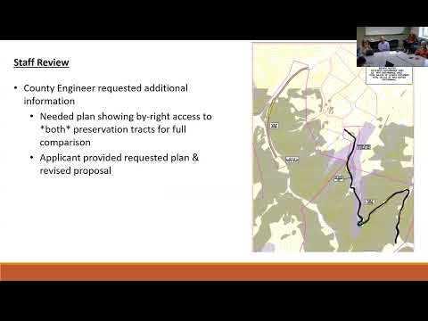
The item before the authority compared two approaches: the “by‑right” accesses shown on the subdivision plat, which would lead from internal subdivision cul‑de‑sacs and switchback up steep slopes and through stream buffers, and an alternative shared routing from Taylor Gap Road that largely follows ridge‑top logging roads and would avoid stream buffers. County staff and the applicant’s engineer presented a comparison showing the shared route would reduce disturbance to critical slopes by approximately 25 percent versus the most recently modeled by‑right accesses; an earlier, less complete analysis had shown a larger benefit. County engineering staff told the authority they had reviewed the additional information and concurred with the general finding that the alternative routing has fewer impacts.
Authority members and staff stressed that a new shared driveway would require a separate overlying access easement to be recorded on top of the existing conservation easement (the 2006 preservation subdivision deed remains in effect). The authority’s legal and policy concerns centered on (1) whether the overlying easement would preserve or weaken the conservation values protected by the original deed, (2) the final design and surfacing of the driveway (permeable versus impervious materials), and (3) precedent: members said they did not want to set a broad precedent allowing large, more intrusive roads across easements without narrowly defined limits.
County staff and the authority’s members discussed design parameters the county applies for residential lot access: a maximum grade standard for safe access (discussed in the meeting as 16 percent), a travel way minimum of roughly 10 feet, and requirements that the travelway extend to within 50 feet of each dwelling and include a clear rectangular zone at least 10 feet wide and 14 feet high. Staff also noted there is no county standard that sets a maximum allowable driveway width—the code sets minimum safety standards rather than a maximum—that means an access easement’s language and any access agreement will be the mechanism to constrain future expansion or commercial uses.
Because those design details affect how the percent reduction in critical‑slope disturbance was calculated, the authority asked the applicant to provide (1) a revised draft of the proposed overlying access easement that would be recorded over A 19 where the shared drive crosses, (2) an exhibit identifying the shared portion of the driveway and the limited segments where impervious surfacing would be allowed (for example where grades exceed the county’s workable threshold), and (3) documentation of the county approvals the project requires (the packet referenced a county waiver/permit number and county engineering review).
Authority members also pressed for clarity about whether the building sites on the preservation tracts remain “locked” by conditions in the original RPD approval and how any change in building‑site siting would affect conservation outcomes. Staff explained that these preservation‑tract building sites were shown in the original subdivision approval and that, for this RPD, those building sites were subject to conditions that constrain relocation; in short, moving building sites would be a separate and more complex step.
The applicant representative said they would return with a revised easement draft and an exhibit showing the proposed route, surfacing strategy, and which short segments—if any—would be paved for stability. Authority members signaled they are likely to favor an access alignment that demonstrably reduces critical slope and stream buffer impacts, provided the final easement language and exhibit limit the width, surfacing, and allowable uses so the action does not erode the conservation values of the underlying deed.
Formal action at the meeting did not include approval of the easement. Instead the authority (a) approved routine minutes early in the meeting and (b) adopted changes to its remote‑participation policy (allowing expanded all‑virtual meetings within the terms discussed), and (c) deferred final action on the shared access easement pending submission of the promised exhibit, detailed engineering assumptions used in the disturbance calculations, and documentation of county approvals. The applicant indicated it will supply the revised easement draft and exhibit for the authority’s review; the authority expects to reconsider the matter after those materials and the county’s engineering approvals are in hand.
What’s next: the applicant will prepare a revised easement draft and an exhibit identifying the shared portion and where impervious surfacing would be used; county staff will finalize engineering review details and any required permits/waivers; the authority will revisit the easement once those documents are complete. The authority asked staff to present clear, page‑by‑page assumptions used in the engineer’s impact calculations so members can verify how the ~25 percent slope‑disturbance reduction was derived.
Direct quotes in this report are drawn from the meeting record and are attributed to speakers who addressed this agenda item.