Get Full Government Meeting Transcripts, Videos, & Alerts Forever!
Get email alerts on the Creek Trail Network Hetch Hetchy topic
No spam. Unsubscribe anytime.
Santa Clara presents Hetch Hetchy corridor options in Creek Trail master plan meeting
Summary
City staff and consultants outlined preliminary alignments, ownership constraints and major engineering challenges for a proposed east–west trail along the Hetch Hetchy right of way; master plan to be completed in 2026 and construction, if funded, could take years.
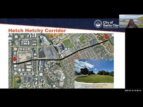
City of Santa Clara staff and their consultants on Tuesday presented preliminary designs and constraints for a proposed Creek Trail along the Hetch Hetchy corridor, describing potential alignments from Calabasas Creek across Great America and Levi’s Stadium to the Guadalupe River and Ulistac Natural Area.
At the virtual meeting, Ralph Garcia, senior civil engineer with the City of Santa Clara Public Works Department and project manager for the Creek Trail Master Plan, opened the presentation and turned it over to Jonna Sokal, principal trail planner for the consultant team, who reviewed corridors, constraints and next steps. “It is a large interdisciplinary team of engineers, landscape architects, planners, environmental consultants, geotech consultants, hydrologic consultants, traffic planners, and survey folks who are working on this project to investigate 3 trail corridors,” Sokal said.
The plan focuses on three corridors—Saratoga Creek, Calabasas Creek and the Hetch Hetchy lands—with the Hetch Hetchy segment discussed in detail. Sokal said most of the Hetch Hetchy corridor right of way within the city is owned by the San Francisco Public Utilities Commission (SFPUC), describing it as “approximately an 80 foot wide right of way” that contains large pipelines conveying drinking water from Yosemite to the Santa Clara Valley. Valley Water was identified as the owner and manager of the creeks the trail would cross and has issued guidance affecting trail placement in creek corridors.
Why it matters: the corridor could create a continuous east–west, off-street route linking parks, transit and major employment centers, including access to commuter and light rail, Mission College and corporate campuses north of Highway 101. but Sokal and staff emphasized substantial implementation challenges, including land-ownership negotiations, pipeline-workspace limits, multiple creek crossings, a constrained railroad corridor and the potential need for a major overcrossing of the Union Pacific/Lafayette rail line.
Key technical and policy points presented
- Ownership and access: Sokal said the SFPUC owns most of the right of way and has in recent years become more cautious about allowing long linear uses on that land; the SFPUC also charges fees and seeks to preserve space for maintenance and emergency staging. “They are wanting to retain workspace for when they have major repairs, events, where they would have physical space to put equipment and put supplies,” Sokal said.
- Corridor geometry and constraints: The corridor crosses three creeks (Calabasas, San Tomas Aquino and the Guadalupe) and major infrastructure including the Capitol Corridor/ACE rail line and the Union Pacific tracks near Great America. Sokal described a preliminary overcrossing concept “similar to the overcrossings that you see at highways” to carry pedestrians and bicycles over Lafayette Street and the rail line; she said the stretch between Calabasas and Great America is largely off the SFPUC right of way, while the segment from the creek to the railroad is “primarily within the right of way because it’s the only place we can put the trail.”
- Cost and schedule: Sokal said cost estimates are not finalized but that each corridor will be “in the tens of millions of dollars,” with expensive items such as the potential overpass adding materially to cost. She estimated the master plan would be completed in 2026 and noted that, if the city advanced a project today, construction could still take four to five years for initial segments, while completing a full corridor could take decades.
- Materials and environmental issues: Sokal said surfacing will be determined in later design, noting that paved asphalt is common outside floodways, while concrete or other surfaces may be required where flood flows are a concern to protect aquatic resources.
Public questions and staff responses
Members of the public asked about SFPUC willingness to allow trail development on its right of way, potential interim crossings for the railroad, connections to Sunnyvale and Mountain View and whether redevelopment projects could dedicate land for the trail. Sokal and city staff described negotiations with SFPUC as a cooperative process that could result in pieces of the trail on private redevelopment sites or through development agreements; they said SFPUC precedent exists both for and against allowing trails and that agreements often include recurring annual fees and conditions rather than a one-time payment.
On the railroad crossing, staff said at-grade crossings are not an option. Regarding interim alternatives, staff confirmed there may be route workarounds—such as using existing crossings near Agnew Road to connect to the San Tomas Aquino Creek Trail—but said narrow rail-side rights of way and security concerns make longitudinal trail construction adjacent to active tracks difficult.
City coordination and next steps
Sokal said the project team has conducted outreach (Earth Day, Bike to Work events, Parks and Recreation Commission, Pedestrian and Bicycle Advisory Committee) and will return with refined alignments and a draft master plan for public comment in the fall and winter. She encouraged continuing coordination with neighboring jurisdictions—Sunnyvale and Mountain View were named repeatedly—and with major redevelopment projects (Patrick Henry area, the Kiley/Keiley development, and the related Great America/Levi’s Stadium properties) as opportunities to secure land dedications or required trail improvements through development review.
No formal actions or votes were taken at the meeting. Staff said funding sources have not been defined and that project implementation would require grant applications, capital budget decisions by the City Council, environmental review, permitting and detailed design.
Ending: The city plans follow-up public meetings (Calabasas Creek meeting scheduled next week, additional outreach in the fall) and invited residents to sign up for updates on the project webpage at santaclaraca.gov/creektrailplan. Sokal and staff said they will refine alignments and provide additional cost and mileage details in future meetings.