Get Full Government Meeting Transcripts, Videos, & Alerts Forever!
Get email alerts on the Land Use Development topic
No spam. Unsubscribe anytime.
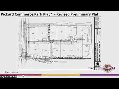
Indianola planners approve revised Pickard Commerce Park preliminary plat after safety, traffic questions
Summary
The Indianola Planning and Zoning Commission on Feb. 25 approved a revised preliminary plat for Pickard Commerce Park that increases lots from eight to 12. Commissioners heard traffic and safety concerns from nearby residents and reviewed a traffic memo concluding a signal is not warranted; a stop sign and trail realignment are planned.
The Indianola Planning and Zoning Commission on Feb. 25 unanimously approved a revised preliminary plat for Pickard Commerce Park that increases the number of lots from eight to 12.
The change — a roughly 50% increase in lots from the earlier plat — alters the southern portion of the site from four larger lots into eight smaller lots while leaving the northern four lots, the detention basin, utilities and landscape-buffer easements largely unchanged.
City staff described the revision as a "significant change" under local code that requires the plat to return to the commission and city council for approval. Jason Lund, an engineer with Steiner Associates representing Itown Investment Group LLC, told the commission that the developer eliminated one access point and realigned the remaining access with South Twentieth Street to reduce highway access points and to minimize conflicts.
Neighbors raised safety concerns at the meeting. Blair and Marilyn Lisonbee, residents at 2100 East Second Avenue in Indianola, said motorists often rear-end at the nearby intersection of South Twentieth Street and Highway 92 and that the additional lots will increase traffic near Pickard Park and a popular trail. "I know that the city is more interested in more tax revenue for them, but safety come first," Blair Lisonbee said.
Lund said the project team provided a traffic-impact memo for the development that reviewed access, anticipated trip generation and sight lines. "It did not warrant a traffic signal," Lund said, adding that the Iowa Department of Transportation determines signal warrants based on multiple factors, including vehicle volumes and recent accident history. He said the revised plat will include a stop sign at the new development access and a realignment of the trail so pedestrians can stand in front of the trail and see traffic in both directions.
Commissioners and staff clarified other technical details: lots in the revised plat range from about 1 acre to 1.86 acres; the outlet parcel remains about 1.77 acres; utilities and landscape buffers remain as previously approved; and the block of the south parcels is subject to the same PUD limits that restrict certain M2 uses, leaving the site with a limited M2 zoning profile rather than full outdoor-storage M2 uses.
Staff also noted that a future site plan will be required for each building and that the precise traffic impact will depend on the actual uses and tenants that occupy each lot. The project team said buyers could combine lots or change uses in the future, and it might be several years before all lots are developed or sold.
After questions and public comment, a motion to approve the revised preliminary plat carried by roll call vote with no opposing votes. Staff invited the Lisonbees and other neighbors to speak after the meeting for follow-up details and to receive the traffic study documentation.
Details from the commission meeting indicated the city will continue coordinating with public works and the Iowa Department of Transportation on any future requests for additional traffic counts or signal warrants as adjacent development proceeds.