Get Full Government Meeting Transcripts, Videos, & Alerts Forever!
Midcoast webinar presents municipal land-use tools — shoreland zoning, overlays, elevated flood standards and tree ordinances
Summary
Regional planners and local officials described local approaches to reduce climate and flood risks — including stronger shoreland rules in Bremen and Bath, watershed overlay districts in Rockport, phosphorus controls, FEMA Community Rating System participation, and municipal tree ordinances — and discussed practical steps for small towns.
Workshop presenters and local planners showcased a menu of land-use tools municipalities can use to reduce hazard risks and guide development.
The session framed land-use controls broadly as local ordinances, zoning, setbacks, overlays, subdivision standards, conservation easements, density bonuses and transfer-of-development-rights programs that communities can tailor to local goals. Presenters emphasized that Maine’s home-rule authority allows municipalities to adopt standards higher than state minimums.
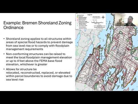
Curtis Brown, land use and transportation planner with the Lincoln County Regional Planning Commission, described Bremen’s shoreland zoning approach and noted that shoreland zoning applies to land within 250 feet of normal high-water lines on ponds, rivers and certain wetlands and within 75 feet of certain streams. Brown said Bremen’s ordinance allows nonconforming structures to be raised to meet local floodplain management elevations or up to four feet above FEMA-based…
Already have an account? Log in
Subscribe to keep reading
Unlock the rest of this article — and every article on Citizen Portal.
- Unlimited articles
- AI-powered breakdowns of topics, speakers, decisions, and budgets
- Instant alerts when your location has a new meeting
- Follow topics and more locations
- 1,000 AI Insights / month, plus AI Chat