Maumee volunteers unveil street tree planting design to restore canopy
Get AI-powered insights, summaries, and transcripts
Subscribe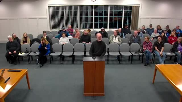
Summary
Volunteers presented a citywide street tree planting design recommending species-by-block scoring and a plan to plant roughly 2,000 trees per year to recover a decades-long canopy loss.
Bill Burry, a volunteer on Maumee’s Tree and Environmental commissions, told Maumee City Council on Dec. 16 that the city has lost roughly 30% of its tree canopy over the past 25 years and needs a structured planting approach to restore it.
Burry said volunteers surveyed every street in Maumee using the Ohio Department of Natural Resources Division of Forestry’s street tree planting design program and scored tree lawns on a 0–20 scale based on factors such as vegetation, soil probe depth, compaction, speed limits, lanes, parking, block length, tree lawn size, overhead electric and curbing or sidewalks. Blocks rated 0–8 were scored as having no trees; 9–11 as poor sites; 12–15 as intermediate; and 16–20 as good sites. Each block segment on the map is color coded and paired with a recommended list of tree species intended to keep at least two blocks between genus and four to six blocks between species.
“The street tree planting design is a well ordered approach to the development of a meaningful master planting design,” Burry said. “When this information is entered into the city's GIS files, there will be a guide to plant the right tree in the right place for the next 50 to 100 years.”
Burry and the volunteer team said the plan aims to plant about 2,000 trees per year for the next 10 years to restore the canopy lost to development, disease and pests including Dutch elm disease and emerald ash borer. The presentation emphasized species diversity to reduce future pest and disease risk and to limit the need for major trimming under utility lines.
Council members asked how the map and inventory would be maintained. Burry said the street-tree inventory will be added to the city’s Esri-based GIS so residents and staff can click on a mapped tree to see species, planting date and other data. Council member Margo Puffenberger and others praised the volunteers’ data-driven approach and encouraged public engagement at the January “movie and presentation” event where the plan and an ODNR representative will present more details.
The presentation included educational materials on how mature tree canopies reduce stormwater runoff by intercepting rainfall (Burry noted that mature trees can intercept a substantially larger share of rainfall than younger trees). Council members and volunteers said the plan is intended to guide plantings for decades and to support nursery supply planning.
Council members did not take a formal vote on a planting ordinance during the meeting; they discussed outreach and the plan’s next public presentation in January.