Planning commission backs variances for Cumberland Oaks PUD; sends amendments to county commission
Get AI-powered insights, summaries, and transcripts
Subscribe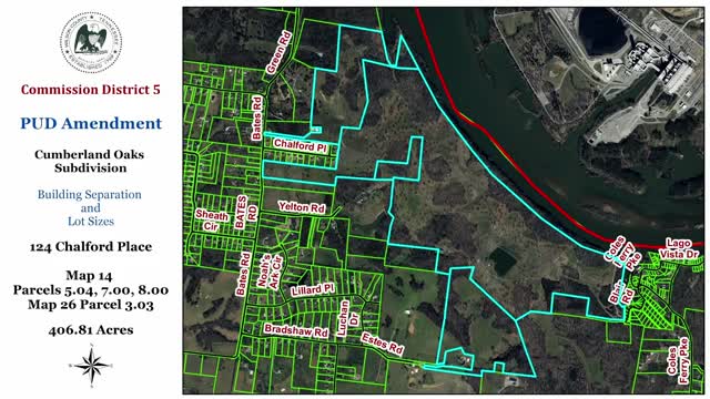
Summary
The Wilson County Planning Commission voted to recommend variances to the Cumberland Oaks PUD that reduce building separation on select lots and set new minimum lot sizes, advancing the developer’s amended master plan to the county commission.
The Wilson County Planning Commission voted Jan. 17 to recommend two design variances that would alter building separation and minimum lot sizes in the Cumberland Oaks planned unit development, moving the amended master plan to the county commission for final action.
The commission approved allowing 20 feet of separation between buildings on 185 affected lots and approved revised minimum lot sizes in three PUD districts — neighborhood center lots as small as 5,180 square feet, neighborhood general lots as small as 6,250 square feet, and waterfront lots as small as 10,000 square feet — while the developer committed to an average lot size of 12,500 square feet for the entire development. The developer and staff said the overall development totals 435 lots.
The amendment request was presented by Caleb Thorn of B & R Lebanon Investments. Thorn said the changes reflect revisions made after earlier hearings and after the county commission approved the underlying PUD zoning in November 2024. “We came out of that meeting with positive recommendation on the zoning for 435 units,” Thorn said, and added the developer reduced an earlier request for 10-foot separations to the 20-foot figure now before the commission.
Staff planner Christopher (surname not specified in the record) told the commission the request does not conform precisely with the PUD language in the Wilson County Zoning Ordinance but that staff’s review found the variances would “have little adverse effect” and would allow the developer to enhance drainage and conservation elements in the design. Christopher said the design as revised keeps most development on the north side of the ridge so more runoff would flow toward the Cumberland River rather than into the Spencer Creek watershed; he also said the project preserves roughly half of the site in open/agricultural use (the original submittal cited about 58% conserved acreage; with the variances that share is closer to the mid-50s percentage).
Commissioners asked about public-service impacts. One commissioner noted a water tank and asked whether construction could cause temporary pressure loss for existing neighborhood connections; Thorn said the developer would work closely with the Lagardo (spelled in record as “Lagardeau”) utility district. Staff advised that the site is within Station 6/Old Legardo Road five-mile ISO response zone for fire and emergency services and that county stormwater staff warned the property contains sinkholes, caves, wetlands and flat or marshy areas that could affect development.
The commission’s votes were procedural recommendations to the county commission. For the separation variance the motion was made by Mr. Noakes and seconded by Mr. Rentro; the chair called for the ayes and the motion carried. For the lot-size amendments a motion was made (maker not specified in the transcript) and seconded by Ms. Weathers; the motion carried. Planning staff said both items will be placed on the county commission’s February agenda.
The developer emphasized design goals that informed the request, including an “age-in-place” mix of housing types, preservation of canopy and open space, an “agrihood” element and buffer areas to avoid encroaching on nearby properties and the Spencer Creek watershed. The property was described in staff materials as about 406.81 acres and identified using Wilson County tax map references.