Get Full Government Meeting Transcripts, Videos, & Alerts Forever!
Missoula County demonstrates interactive floodplain map viewer with preliminary FEMA layers
Summary
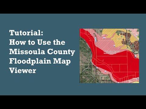
Missoula County Floodplain Administrator Matt Heimel demonstrated an online Floodplain Map Viewer that overlays preliminary FEMA flood mapping for the Clark Fork, Bitterroot and Rock Creek watersheds onto the county GIS, and detailed how property owners, realtors and engineers can use the tool and contact county staff for help.
In a recorded presentation, Missoula County Floodplain Administrator Matt Heimel demonstrated the county's Floodplain Map Viewer, an online tool that integrates Federal Emergency Management Agency (FEMA) preliminary floodplain data with Missoula County GIS layers to show how mapped flood hazards intersect specific parcels.
“This is our local online tool for viewing flood hazard information, and this mapping tool is integrated into our entire county GIS system, which allows it to connect not only with floodplain data, but also parcel information, zoning, permits, and other layers,” Matt Heimel said.
The tool is available from the Missoula County Floodplain Administration website and…
Already have an account? Log in
Subscribe to keep reading
Unlock the rest of this article — and every article on Citizen Portal.
- Unlimited articles
- AI-powered breakdowns of topics, speakers, decisions, and budgets
- Instant alerts when your location has a new meeting
- Follow topics and more locations
- 1,000 AI Insights / month, plus AI Chat