Get Full Government Meeting Transcripts, Videos, & Alerts Forever!
Get email alerts on the Floor Area Ratio topic
No spam. Unsubscribe anytime.
Marion County commissioners debate keeping current floor area ratio limits, ask staff for local data
Summary
County planners and consultants recommended leaving commercial floor area ratio (FAR) ranges in the comprehensive plan unchanged while staff were directed to produce local development data and a targeted map of where higher FAR should apply by 2050.
Marion County commissioners on Monday debated whether to change the county's commercial floor area ratio (FAR) ranges as part of an early action report (EAR)-based update to the comprehensive plan, ultimately directing staff to return with data and targeted mapping rather than immediately lowering the FAR caps.
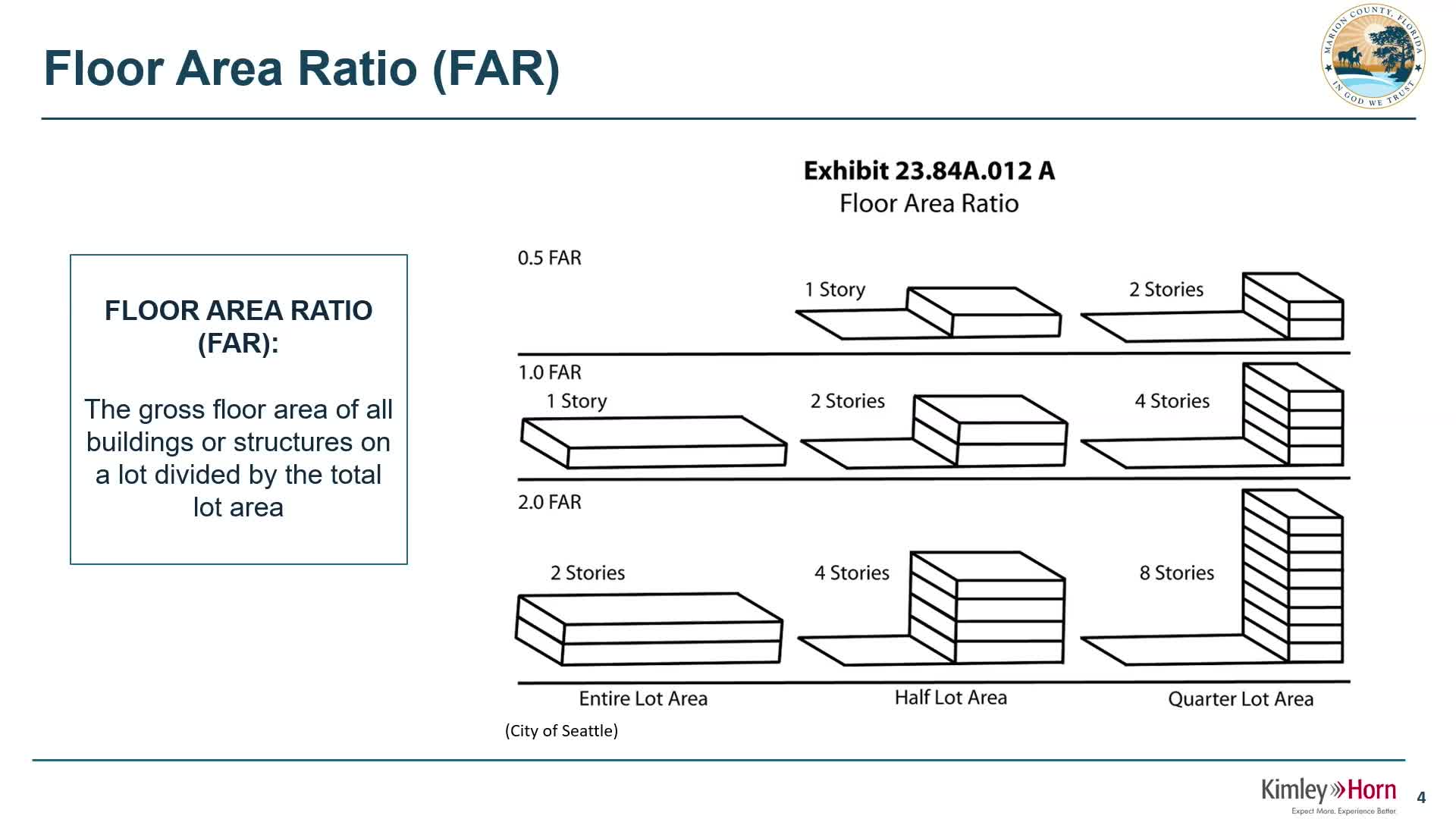
Blair Knighting, a consultant with Kimley-Horn contracted for the EAR-based amendments, told the board that FAR measures "the gross floor area of all the buildings that you plan to put on your parcel divided by the actual lot size," and that FAR is typically used for nonresidential development.
Knighting said Marion County's plan already contains a range of FAR values, with a low of roughly 0.35 in rural activity areas and a high of 2.0 in employment-center land-use categories, and recommended keeping those existing ranges for now.
Several commissioners pushed back. Commissioner Zalick said developers sometimes use a high commercial FAR as a bargaining chip when seeking land-use changes, and argued the county may be "giving away trips" on the road network because some conversions treat commercial entitlements as if they generate the traffic of intense commercial uses.
"We're planning for 2050," Knighting replied, noting the county's urban growth boundary and the possibility that some areas will become denser over time. He also said certain uses, such as hospitals, can require higher FARs and that those would still come before the county in a planned-unit development or land-use amendment.
Amber Gardner, a traffic engineer with Kimley-Horn, told the board that when applicants seek a comprehensive-plan amendment they commonly present traffic analyses that argue the proposed land-use change "would not result in a greater number of trips compared to the existing future land use." She said those analyses are presented to support a land-use amendment but do not themselves grant concurrency or automatic road capacity.
County staff and some commissioners said local construction patterns suggest most commercial projects build at FARs well below 1.0. Commissioners asked staff to compile local-build FAR data and offer recommendations showing where higher FAR allowances should be concentrated, such as inside proposed publicly supported areas (PSAs) or a more narrowly drawn portion of the urban growth boundary.
Staff said they will provide market and vacancy analyses and that the county is acquiring software (ArcGIS Urban) to better model vacant parcels, forecast likely development, and map where different FARs would be appropriate. Knighting said the county's state transmittal deadline for the EAR-based amendments is Jan. 28, 2026, and that the team plans additional public workshops before final redlines are transmitted.
Commissioners did not adopt an immediate change to FAR ranges. Instead, they directed staff to return with empirical data on what is actually being built in Marion County, mapped recommendations for where higher FAR should be allowed, and an analysis of potential effects on roads and entitlements.
The board scheduled the next workshop for Feb. 24 to continue work on step-down approaches and other EAR topics.