Get Full Government Meeting Transcripts, Videos, & Alerts Forever!
Oxnard launches Local Coastal Program update focused on sea level rise
Summary
City-contracted consultants presented preliminary sea level rise vulnerability maps for four coastal planning areas and outlined a menu of adaptation options, and invited public input via email and a project website.
Carolyn Groves, a coastal planner with Dudek, told viewers that Dudek is contracting with the City of Oxnard to lead an update of the city’s Local Coastal Program, or LCP, with a focus on planning for sea level rise and related coastal hazards.
The presentation described the purpose, schedule and early results of a vulnerability assessment for Oxnard’s coastal zone and invited public comment. “This project is gonna determine how Oxnard adapts to sea level rise for many years to come,” Groves said, adding that the consultant team will incorporate public and council feedback before finalizing adaptation recommendations.
The LCP implements the California Coastal Act at the local level and must be certified by the California Coastal Commission. Groves said the update responds to recent state legislation that requires LCPs to plan for sea level rise and to guidance from state agencies, including the Ocean Protection Council, and technical data from the U.S. Geological Survey.
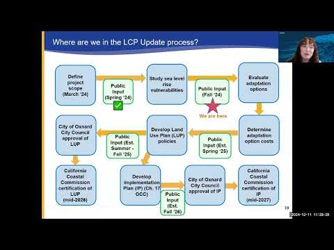
Project schedule and public input
Groves said the update began with a project kickoff in March and one community meeting; the current phase centers on vulnerability assessment and public input. After the public-comment phase the team will…
Already have an account? Log in
Subscribe to keep reading
Unlock the rest of this article — and every article on Citizen Portal.
- Unlimited articles
- AI-powered breakdowns of topics, speakers, decisions, and budgets
- Instant alerts when your location has a new meeting
- Follow topics and more locations
- 1,000 AI Insights / month, plus AI Chat