Get Full Government Meeting Transcripts, Videos, & Alerts Forever!
Get email alerts on the Sea Level Rise topic
No spam. Unsubscribe anytime.
Oxnard launches Local Coastal Program update focused on sea level rise
Summary
City-contracted consultants presented preliminary sea level rise vulnerability maps for four coastal planning areas and outlined a menu of adaptation options, and invited public input via email and a project website.
Carolyn Groves, a coastal planner with Dudek, told viewers that Dudek is contracting with the City of Oxnard to lead an update of the city’s Local Coastal Program, or LCP, with a focus on planning for sea level rise and related coastal hazards.
The presentation described the purpose, schedule and early results of a vulnerability assessment for Oxnard’s coastal zone and invited public comment. “This project is gonna determine how Oxnard adapts to sea level rise for many years to come,” Groves said, adding that the consultant team will incorporate public and council feedback before finalizing adaptation recommendations.
The LCP implements the California Coastal Act at the local level and must be certified by the California Coastal Commission. Groves said the update responds to recent state legislation that requires LCPs to plan for sea level rise and to guidance from state agencies, including the Ocean Protection Council, and technical data from the U.S. Geological Survey.
Project schedule and public input
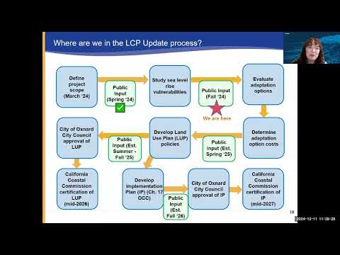
Groves said the update began with a project kickoff in March and one community meeting; the current phase centers on vulnerability assessment and public input. After the public-comment phase the team will evaluate adaptation costs, propose land-use policies for the LCP land use plan and the implementation (zoning) provisions, and sequentially seek City Council approval and Coastal Commission certification. Groves said the team expects to seek public input on draft land-use policies in early 2026 and on implementation provisions in late 2026 before the state certification process in 2026–2027.
Vulnerability mapping: scenarios and planning areas
The team mapped a baseline and two representative sea level rise scenarios chosen for coordination with neighboring jurisdictions: 3.3 feet (about 1 meter) and 6.6 feet (about 2 meters). Groves emphasized uncertainty in timing and said the scenarios are intended to cover a range of plausible futures rather than predict exact years.
Maps and discussion were organized by the four planning areas inside Oxnard’s coastal zone: (1) McGrath / Mandalay Beach at the Santa Clara River mouth; (2) Oxnard Shores; (3) Channel Islands / Lower Harbor; and (4) Ormond Beach. Groves noted multiple jurisdictional overlaps: significant portions of beaches and the harbor interior are under Ventura County jurisdiction and therefore outside Oxnard’s LCP.
Key takeaways from the vulnerability assessment
- Erosion: For most planning areas the projected shoreline erosion corridor under the two scenarios is relatively narrow; some beaches (Groves cited Hollywood Beach) are wide and expected to remain relatively extensive even under the modeled erosion scenarios.
- Flooding: Flooding increases markedly in the higher scenario (6.6 feet). Groves identified several areas of concern: McGrath campground and adjacent low-lying areas near the Santa Clara River; the northern/upper portion of Oxnard Shores; the middle peninsula and eastern portions of the harbor; and interior portions of the Ormond Beach planning area that abut Ventura County lands. In several places the maps show flooding from multiple sources (ocean wave run-up plus inundation from interior channels or riverine flow).
Adaptation toolbox presented
Groves presented five categories of adaptation measures the team is evaluating: hard engineering (seawalls, revetments, elevation of structures), nature-based approaches (beach nourishment, dunes, vegetation, kelp/reef enhancement), hybrid solutions (engineered structures designed to support habitat), operational strategies (temporary flood barriers, emergency notification, evacuation), and planning strategies (policy updates, regional coordination, managed retreat). “These measures I’m about to go through are all potential draft measures we’re evaluating right now,” Groves said, stressing that the city has not decided on specific measures or locations.
Groves noted tradeoffs: hard structures can protect specific sites but may accelerate erosion elsewhere; nature-based approaches can buffer wave energy and preserve habitat but work differently by location; hybrids aim to combine benefits. She described managed retreat as a planning strategy where the city or higher-level government could acquire and repurpose very high‑risk properties to uses with higher adaptive capacity.
Next steps and how to participate
Groves asked stakeholders to review the maps and provide feedback by email to lcp@oxnard.org and through the project website, which will list documents, meeting notices and an email sign-up. The presentation reiterated that public input will shape which adaptation options the city advances into policy and implementation chapters of the updated LCP.
Ending
Groves closed by thanking viewers for participating in the civic process and reiterating the request for written comments and questions via the project email address and website.