Get Full Government Meeting Transcripts, Videos, & Alerts Forever!
Get email alerts on the Traffic Signal Protected Intersection topic
No spam. Unsubscribe anytime.
San Mateo advances signal and partial protected-intersection plan for Hillsdale Boulevard and Alameda de las Pulgas
Summary
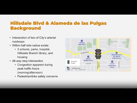
City staff presented a revised plan to install a traffic signal, dedicated left-turn pockets and partially protected corners at the intersection of West Hillsdale Boulevard and Alameda de las Pulgas, saying the intersection met traffic-signal warrants and that construction is fully funded.
City staff presented a revised plan to install a traffic signal, dedicated left-turn pockets and partially protected corners at the intersection of West Hillsdale Boulevard and Alameda de las Pulgas, saying the intersection met traffic-signal warrants and that construction is fully funded.
The project, described during a San Mateo City virtual meeting, aims to reduce neighborhood cut-through traffic, shorten vehicle delay and improve pedestrian and bicycle safety near three nearby schools — Hillsdale High School, Abbott Middle School and Laurel Elementary School. Staff said prior warrant studies in 2018 and a consultant verification in 2023 showed the intersection qualifies for a signal.
Staff member Singh, the project presenter, said the revised design responds to community feedback collected since a January 2024 public meeting and additional outreach in 2024–2025, including a neighborhood canvass and meetings with the three schools and the Sustainability and Infrastructure Commission. "The project is fully funded for construction, and we'll likely bid and award the project through city council in winter of this year into 2026 and be able to implement the project and traffic signals by 2026," Singh said.
The design that staff presented adds dedicated left-turn pockets and left-turn signals on Alameda, protected corners on two of the four quadrant corners, pedestrian refuge islands, curb extensions and special bike-crossing markings. Staff said the protected corners and a dedicated pedestrian phase will reduce pedestrian crossing distances and improve visibility at conflict points. The design also includes rubber speed wedges to slow right turns and lane reconfiguration with 10-foot minimum lane widths.
Staff described trade-offs in the design. To provide left-turn pockets, the plan would remove two to four median trees in the intersection and lengthen left-turn lanes; staff said the implementation will require coordination with Parks and Recreation about replacement plantings. They also said swept-path analyses using a standard small design delivery truck showed two corners could not safely include protected corners without preventing those turning movements.
Residents at the meeting urged the city to minimize tree removals and to replace removed trees. Kautam, a resident, asked, "Will there be more trees planted?" Singh responded that coordination with Parks and Recreation is required and that the city would follow up with specifics.
Other public concerns included drainage at corners that pond after rain, the location of a SamTrans bus stop near Fernwood, and whether the partial protected-intersection design overly accommodates delivery trucks at the expense of pedestrian safety. Joe, a city staff member, said the design maintains existing drainage infrastructure except where inlet locations shift and that the medians will be designed to avoid pooling in front of curb ramps. Staff offered to follow up with SamTrans on the bus-stop placement.
Staff cited results from their traffic analysis showing current delays of roughly 40–60 seconds in the morning and afternoon peak periods at the stop-controlled intersection, with projected delays after signal installation dropping to roughly 10–15 seconds. Staff also said the new 100-foot left-turn pockets would accommodate about five vehicles queued while waiting for a turn signal, based on design queue estimates.
The presentation referenced industry design guidance used to shape the project, including the National Association of City Transportation Officials Urban Street Design Guide (NACTO), and the San Mateo General Plan 2040 circulation element policies on complete streets, pedestrian and bicycle networks and roadway operations.
The project team solicited additional, detailed feedback on walking and biking comfort, traffic operations, and construction and post-construction education and signage, and provided a QR code and contact email for follow-up questions.
City staff said there were no votes or formal council actions at the meeting; the next steps described were continued outreach, design refinement, coordination with Parks and Recreation and SamTrans as needed, and a planned bid-and-award process to go before the City Council in winter 2025–2026.
Less critical details discussed included maintaining most on-street parking outside the immediate buffered bike and turn-pocket areas and limited ability to add protected corners at all four quadrants because of vehicle turning-radius requirements.