Coconino County staff recommend adopting larger local floodplain after August 2023 floods
Loading...
Summary
Coconino County staff and consultants presented new hydrologic and hydraulic modeling for Coconino Wash and its tributaries near Tusayan and recommended the county recognize a larger local floodplain and revise local regulations to treat that area the same as FEMA special flood hazard areas.
Coconino County staff and consultants presented new hydrologic and hydraulic modeling for Coconino Wash and its tributaries near Tusayan and recommended the county recognize a larger local floodplain and revise local regulations to treat that area the same as FEMA special flood hazard areas.
Ian Sharp, civil engineer with JE Fuller, told the board that the current FEMA Zone A maps are “basically a Sharpie on a map” and do not reflect the true flood risk. Sharp said the district’s FEMA-quality modeling shows a much larger inundation area that includes tributaries and approaches Tusayan.
The presentation reviewed the August 2023 storm, which Sharp summarized as producing about 3.5 inches of rain at the watershed center and roughly 0.5 inches at the watershed edge. A wastewater-treatment-plant gauge recorded a flow depth of 1.4 feet; staff back-calculated that event to an estimated 1,400 cubic feet per second (CFS). Sharp said the district’s modeling yields recurrence discharges of about 940 CFS for a 10-year event, 3,200 CFS for a 25-year event and 10,000 CFS for a 100-year event.
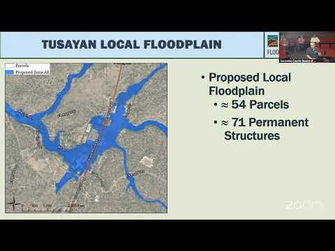
Sharp compared parcel and structure counts based on the existing Zone A versus the modeled local floodplain: Zone A currently shows 21 parcels and 49 permanent structures in the floodplain, while the modeled local floodplain would affect 54 parcels and possibly 71 structures. Staff said those counts will be refined during outreach with landowners.
To address the discrepancy, staff proposed defining a regulatory floodplain that would include both FEMA special flood hazard areas and the modeled local floodplain. Under the proposed approach, development in the local floodplain would be subject to the same requirements as FEMA-designated areas, including building above the 100-year flood and performing no-adverse-impact analyses. Staff noted that the formal FEMA letter-map revision process is lengthy and can take multiple years; recognizing a local regulatory floodplain would provide interim regulatory authority while any FEMA revision proceeds.
Staff also discussed insurance and disclosure implications. Sharp said flood insurance is recommended but not required simply by being in a locally recognized floodplain; there is no automatic mechanism to force insurance for parcels placed into a local floodplain, so the county will need to conduct outreach and education for buyers and landowners.
Staff said they are working with the district attorney, John Gaylord, to draft ordinance language; the district attorney will prepare and sign off on the revisions before they return to the board. An unnamed supervisor praised the town of Tusayan, the district and the consultant team for pursuing the work and said officials have a “moral and ethical obligation” to reflect current flood risk after the August 2023 event, which closed Highway 64 and temporarily stranded some schoolchildren.
A Tusayan resident, Lorraine Devale, thanked staff and consultants for the county’s work on the mapping and outreach. Staff told the board the item will return for future consideration after further outreach and drafting by the district attorney.