Clark County transfers more than 700 logs from Spud Mountain to East Fork Lewis River reconnection project
Loading...
Summary
Clark County completed a forest-health thinning this summer at Spud Mountain and transferred more than 700 logs to an East Fork Lewis River reconnection and habitat-restoration project, county staff said.
Clark County completed a forest-health thinning this summer at Spud Mountain and transferred more than 700 logs to an East Fork Lewis River reconnection and habitat-restoration project, county staff said.
County staff described the work as part of the county's sustainable forestry program, which they said covers about 4,500 acres and seeks certification from the Forest Stewardship Council and the Sustainable Forestry Initiative. "As part of the county's sustainable forestry program, the latest forest health thinning activity was completed this summer at Spud Mountain," a county staff member said.
The county said a previously completed inventory recommended thinning eight to 10 years after that assessment, and a follow-up evaluation indicated it was time to act. "When I came onto the county about 9 years ago, I did an inventory on our Spud Mountain property, and that indicated that we should do a thinning in between 8 to 10 years from then," a county staff member said.
County staff and the Lower Columbia Estuary Partnership described two linked goals for the work: reduce wildfire risk on county forestland and use large wood to restore river-floodplain processes downstream. "Selective thinning allows the remaining trees to receive more resources such as sunlight and water and reduces fuel loading and wildfire risk," a county staff member said. Another staff member added that thinning "definitely reduces the overcrowding, which also reduces the wildfire risk and potential risk for pests or other pathogens."
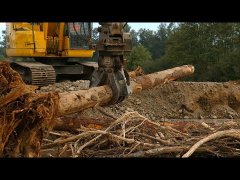
Some logs were sent by the contractor to be milled for lumber or utility poles, the county said. The county reserved a set of larger trees specifically as habitat logs for the East Fork Lewis River reconnection project and noted a recent county acquisition of the former Ridgefield gravel pits, which are a central component of the river work.
The Lower Columbia Estuary Partnership, which designed and manages the reconnection project, said crews diverted the river to the north during the summer low-flow construction window to work in the channel and gravel pits. "To work in the river channel and gravel pits, the river was temporarily diverted to the right or the north side. This was done in the drier, low flow of summer," a project representative said.
Project crews removed levees and berms that had constrained the river, recreated side channels and placed wood in those channels. Project staff said those engineered and naturalistic structures aim to slow and spread water across the floodplain, create pools and hiding places for fish, and capture organic matter that supports aquatic insects and the food web. "The project aims to install over 5,000 logs," the project representative said.
Clark County contributed more than 700 logs from Spud Mountain to the project, and project managers said the remainder of the logs will come from other locally sourced, sustainably managed forests and from trees removed during construction. "The third reason is the logs capture leaves and other organic material, which is habitat for aquatic insects and a vital component to the food chain. Clark County transferred more than 700 logs from its Spud Mountain property to the project," a county staff member said.
Project engineers said they designed 13 types of habitat structures and anchored them by burying logs in banks or attaching them to vertical pile logs to prevent downstream displacement. "We designed the habitat structures to look as natural and function as naturally as possible, but they're also highly engineered to ensure that they stay on-site and they don't float downstream," the project representative said.
During the first construction window, crews filled five of the eight gravel pits. Project staff said they plan to return next year to dewater the remaining pits, rescue fish, continue construction and aim to wrap up that construction phase by October of that year. The partnership representative said crews will then continue longer-term work to finish the overall project.
Until the project is completed in fall 2026, the river will remain closed to boaters and other recreationists for 3 miles downstream of Daybreak Regional Park, county staff said. With the rainy months approaching, the partnership plans to plant tens of thousands of native plants and posted volunteer opportunities at estuarypartnership.org/volunteer.
Details not specified in the meeting transcript include the total project budget and specific funding sources for construction and plantings.