County consultants propose new local floodplain map for Tusayan, recommend ordinance change
Loading...
Summary
Consultants working with Coconino County presented a locally derived floodplain map for Tusayan and urged the county to revise its ordinance so both FEMA special flood hazard areas and the new local floodplain would be treated as a single regulatory floodplain.
Consultants working with Coconino County presented a locally derived floodplain map for the Tusayan area and recommended the county revise its floodplain ordinance so the county will treat both FEMA special flood hazard areas and the local floodplain as a single “regulatory floodplain.”
Ian Sharp, a civil engineer with JE Fuller, said he led hydrology and hydraulic modeling for the project and that the team produced discharge estimates and flood inundation mapping suitable for submission to FEMA. "My name is Ian Sharp, civil engineer with JE Fuller. Been with JE Fuller for 20 years, and most of my career has been this right here," Sharp said when he introduced the technical work.
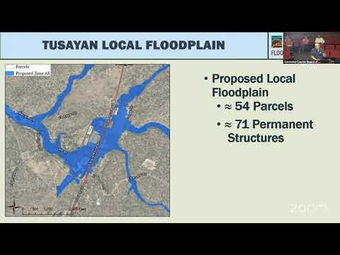
The consultants showed two footprints: the existing FEMA Zone A, which they described as an older, smaller boundary, and a larger locally modeled floodplain that includes tributaries and additional inundation areas. Sharp said the older Zone A delineations were likely done on paper in the 1970s–1980s and later digitized, producing errors and an underestimation of risk. "It's basically a Sharpie on a map," he said of the older maps.
The presentation summarized storm and flow data from an August 2023 event. Consultants said the core of the watershed received about 3.5 inches of rain in roughly six hours, an intensity they described as near a 25-year storm for that core, and that the wastewater treatment plant gauge recorded a depth of 1.4 feet. Using that gauge data, the consultants estimated the peak flow that day at about 1,400 cubic feet per second (cfs). Their modeled recurrence discharges for the watershed were 940 cfs for a 10-year event, 3,200 cfs for a 25-year event and 10,000 cfs for a 100-year event.
Sharp said the existing FEMA Zone A footprint currently touches 21 parcels and 49 permanent structures in the town area. The locally modeled floodplain would affect roughly 54 parcels and possibly 71 structures, he said.
Because a formal Letter of Map Revision (LOMR) or Conditional LOMR to FEMA can take several years, staff recommended the county adopt a local regulatory approach in the near term. Under the proposal, the county’s regulatory floodplain would include both the FEMA special flood hazard area and the locally modeled floodplain so both areas would be subject to the same development standards. Staff described those standards as consistent with FEMA-oriented practices: build above the 100-year flood and complete a no-adverse-impact analysis to avoid shifting risk to neighboring properties. Where FEMA-designated zones remain, the FEMA LOMR/CLOMR process would still apply for federal map changes.
Staff said they have begun outreach to affected landowners to explain how the change would affect parcels and that they will encourage—but not require—property owners to carry flood insurance. "Because you're in a local floodplain, that doesn't mean you have to have flood insurance," Sharp said; he added that education is needed because local designation does not automatically trigger disclosure at property sale.
Presenters said they are coordinating the ordinance revision with the district attorney. Lucinda (staff member) said district attorney John Gaylord will draft and sign off on the ordinance language before it returns to the board for formal consideration.
A board member who did not give a name described the August flood’s local impacts—including a temporary closure of Highway 64 and instances of students for Grand Canyon Unified School District who could not get home—and said the board has a "moral and ethical obligation" to adopt accurate floodplain maps. Lorraine Devale, who identified herself and an address in Tusayan, thanked county and district staff for the work.
Staff said the item will return to the board with drafted ordinance language and additional outreach documentation. No formal motion or vote on an ordinance change occurred at this meeting.