Lifetime Citizen Portal Access — AI Briefings, Alerts & Unlimited Follows
Casper unveils redesigned website, expands GeoSMART mapping and e‑notifications
Loading...
Summary
City staff demonstrated a newly launched city website and updated GeoSMART mapping portal that add mobile‑friendly navigation, emergency alerts, e‑notifications and weekly/daily GIS data updates; staff urged residents to try the new tools and send feedback.
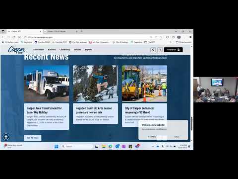
City of Casper staff showed the City Council a newly redesigned municipal website and an upgraded GeoSMART public mapping portal during a July 29 special meeting.
"We went live with the website at the end of last week," Michael Subchak, the city’s project lead, told the council. He said the site was rebuilt by vendor Revise to add functionality and to meet federal ADA accessibility requirements that take effect in April 2026.
The site emphasizes citizen‑focused navigation rather than department pages, Subchak said, and includes quick links for commonly used services (landfill, online payments, agendas and minutes, pothole reporting and job applications). A new alerts feature will pop up emergency notices — such as snow‑closure announcements — rather than relying on overwritten links. The site also offers an accessibility widget (larger text, dyslexia modes and cursor options) and an option for residents to sign up for e‑notifications via email or text for specific pages (alerts, news, agendas).
Denise Wiskup, the city’s regional GIS administrator, demonstrated the GeoSMART portal, a cooperative mapping platform that consolidates municipal and Natrona County datasets into interactive public 'experiences.' "This data is updated weekly and in some instances daily," Wiskup said, noting live updates for road closures and frequent updates to address and utility layers. She also said lidar and 6‑inch imagery collected in 2025 will be released later this winter and will update contours and elevation data.
Council members praised the calendar and mobile views and asked about search engine indexing and subscription granularity. Subchak said Google may take up to two weeks to crawl the new site and that staff can expand subscription categories — for example, adding boards and commissions or venue‑specific calendars — as the site rollout continues.
Staff asked the public to test the site and use an embedded survey to report errors or suggested improvements. Subchak said the site currently contains roughly 416 pages and more than 2,000 documents and that staff will continue to refine content and add vendor and animal licensing features.
Next steps: staff will continue final content work, add subscription categories on request and publish the GeoSMART lidar/imagery updates when available. Councilors encouraged staff to monitor search‑engine results and report back if issues persist.