Committee reviews map to designate trails and land to Simons Center; Simons urges trails remain public
Get AI-powered insights, summaries, and transcripts
Subscribe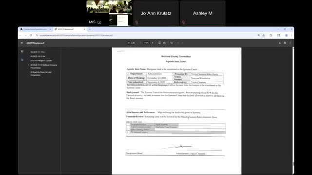
Summary
Committee reviewed a proposed boundary map for land to be designated to the Simons Center, discussed stormwater, trail easements and preservation, and deferred final action to a future meeting while asking legal and engineering follow-ups.
County staff and a Simons Center representative reviewed a proposed orange-dashed boundary showing land the county might designate to Simons, explaining how trail connections, stormwater management and solar-panel siting factor into the proposal.
Staff said the draft boundary keeps the hillside for potential development and squares off trail-adjacent parcels while leaving room for a trailhead and parking. The staff presentation advised that stormwater-management features such as bioswales would be required if infrastructure is added. A Simons Center speaker said the organization does not intend to charge for trail use and would prefer the trails remain public even if Simons changes ownership.
Committee members raised preservation tools such as deed restrictions, easements, or memoranda of understanding to ensure long-term public access. Staff recommended asking an attorney to identify the best legal instruments for preserving trail access if ownership changes in the future. The committee asked for those legal options and additional map clarifications at the next meeting; no land transfer motion was recorded at this meeting.