Get Full Government Meeting Transcripts, Videos, & Alerts Forever!
Feasibility study finds pedestrian bridge options for Eau Claire River corridor but flags wetlands, railroad and cost hurdles
Summary
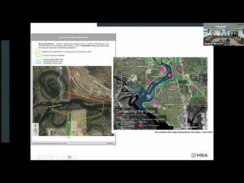
An MSA feasibility study presented to the Village Parks & Rec Committee evaluated three alternatives for a multi-jurisdictional trail across the Eau Claire River; study authors highlighted wetlands, railroad coordination, geotechnical needs and estimated costs of roughly $19.2M–$22M, with DOT safety metrics cited as a key funding rationale.
An MSA consultant presented findings from an Eau Claire River feasibility study at the Village Parks & Recreation Committee meeting, outlining three alternatives to improve bike and pedestrian access between Grossman Drive and Kent Street and to connect to Wausau’s recreational complex.
The study evaluated a no-build option and two bridge alternatives: an east-side pedestrian bridge of about 660 feet and a longer, more elevated west-side structure. Dan Borgert of MSA, who led the technical presentation, described design constraints including wetland delineation, floodplain impacts, railroad coordination and geotechnical investigation needs. "The bridge on the east side would be about 660 feet long," Borgert said, summarizing a primary sizing outcome for one favored alternative.
Why it matters: Grand Avenue carries an estimated 17,000–23,000…
Already have an account? Log in
Subscribe to keep reading
Unlock the rest of this article — and every article on Citizen Portal.
- Unlimited articles
- AI-powered breakdowns of topics, speakers, decisions, and budgets
- Instant alerts when your location has a new meeting
- Follow topics and more locations
- 1,000 AI Insights / month, plus AI Chat