Get Full Government Meeting Transcripts, Videos, & Alerts Forever!
Get email alerts on the Land Use Development topic
No spam. Unsubscribe anytime.
Westminster commission hears plan to add 35 homes at Wakefield Valley, pauses for legal review and continues hearing
Summary
At a Sept. 18 public hearing, the Westminster Planning & Zoning Commission heard applicant presentations on DP 24‑01, a proposed amendment to allow 35 single‑family homes on Parcel W and to dedicate Parcel X as open space; commissioners pressed for more traffic and water documentation, voted to consult counsel about a prior lawsuit in closed session, and continued the hearing to an October meeting while asking staff to circulate full materials.
The Westminster Planning & Zoning Commission on Sept. 18 heard presentations and public testimony on a proposed amendment to the Wakefield Valley development plan (DP 24‑01) that would allow up to 35 single‑family detached homes on Parcel W and dedicate Parcel X as open space to Carroll Lutheran Village or the city.
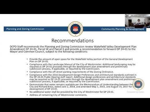
The change, described by staff and the applicant as the fifth amendment to the original Wakefield Valley general development plan, was presented by city staff and the applicant team, who summarized acreage, density, open‑space calculations and water allocations. Staff said the subject parcels total roughly 38.29 acres (Parcel W) and 16.09 acres (Parcel X) and recommended the commission forward a favorable recommendation to the mayor and common council subject to several conditions, including documentation of open space, compliance with the city’s landscape and parking standards, and a demonstration that water for the project exists per an existing memorandum of understanding.
Why it matters: The proposal alters how previously designated Wakefield Valley acreage would be developed and how open space is dedicated, while touching on water supply, traffic impacts and long‑standing plan history dating to a 1978 development plan. Commissioners emphasized the need for clear technical studies and asked that the public record remain open ahead of a final council decision.
What presenters said Applicant land‑use consultant Marty Hackett laid out the plan’s numbers, comparing the 1978 plan, existing built units and the proposed amendment. “In the 1978 plan there were 768 density units that were originally approved,” Hackett said; under the current proposal the applicant and staff calculated an overall Wakefield plan total near 643 units and an average density of about 1.24 units per acre. Hackett also said the proposal increases overall open space within the Wakefield plan to roughly 43.2% from about 41% shown in the 1978 plan.
Staff confirmed the application’s procedural history and flagged a clerical error in the meeting advertisement: “The advertisement incorrectly refers to the property’s parcel W and X in Zone PD4, where the property is Zone C conservation,” staff said, adding that the city attorney had been consulted and that staff considered the mislabeling non‑substantive to the hearing.
Water, traffic and design Applicant representatives told the commission that water allocations tied to prior memoranda of understanding are available and that roughly 60 single‑family allocations remain for use on the Wakefield property; staff made documentation of water availability a condition of recommendation. On traffic, the consultant updated a July 2025 study and described methodology nuances (critical‑lane volume and Highway Capacity Manual comparisons), saying the 35‑lot subdivision would generate a modest number of peak‑hour trips — on the order of about seven evening peak trips — and that studied intersections would not drop below acceptable levels.
Design presenters described lots generally ranging between about one‑third and one‑half acre, retention of existing tree screens and buffers, proposed sidewalks and trail connections to adjacent parkland, and bio‑retention stormwater facilities (engineers said the planned facilities are likely shallow bio‑retention areas rather than permanent wet ponds).
Public testimony and applicant background The property owner and applicant representatives recounted the site’s long history, including past donations of land to the city and earlier development negotiations tied to water availability. The applicant described proposed house products as larger single‑family homes (roughly 2,800–3,800 sq ft) and said pricing would reflect market conditions.
Commission actions and next steps Beyond the substantive presentations, the commission took three formal procedural actions: it approved the prior meeting summary (11/21/2024); it voted to go into closed session to consult with counsel about the implications of a prior lawsuit involving the property (citing Maryland Code, General Provisions Article §3‑305(b)(7)); and it voted to continue the public hearing to an October meeting while leaving the record open and requesting that staff circulate the correct traffic study and the full submittal documents to commissioners.
Commissioners debated the exact October date (members mentioned Oct. 21 and Oct. 25) and asked staff to confirm the date and re‑advertise if necessary. Staff committed to distribute an electronic copy of the full submittal and attachments to commissioners before the continued hearing.
The commission’s favorable recommendation would still be advisory to the mayor and common council; any final changes (subdivision layout, landscaping, detailed engineering) will be reviewed in later subdivision and site‑plan stages if council moves forward.
The hearing was continued pending additional materials and counsel’s advice; the commission will reconvene the public hearing in October once staff confirms logistics and provides the requested documents.