Get Full Government Meeting Transcripts, Videos, & Alerts Forever!
Jefferson County explains Conifer water rules, WAW model and referral process amid bike‑park concerns
Summary
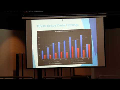
County planning staff described Conifer‑specific water policies, the Mountain Groundwater Overlay District and the Water Availability Analysis (WAW) ArcGIS model used to evaluate development water supply; residents raised concerns about a proposed Shadow Mountain bike park and whether the watershed association had been formally referred.
Jefferson County planning staff told Conifer residents that the county applies extra water policies to mountain area plans and uses a standardized Water Availability Analysis (WAW) to evaluate water supply for rezonings, plats and building permits.
"We have 16 additional water policies that we would look at when a development proposal comes in," Heather of Jefferson County Planning & Zoning said, describing the Conifer plan’s supplemental policies for groundwater, well testing and clustering systems.
She explained the Mountain Groundwater Overlay District (adopted in February 2007) applies mainly above about 6,400 feet and only where areas are not already served by a water and sanitation district…
Already have an account? Log in
Subscribe to keep reading
Unlock the rest of this article — and every article on Citizen Portal.
- Unlimited articles
- AI-powered breakdowns of topics, speakers, decisions, and budgets
- Instant alerts when your location has a new meeting
- Follow topics and more locations
- 1,000 AI Insights / month, plus AI Chat