Get Full Government Meeting Transcripts, Videos, & Alerts Forever!
Get email alerts on the Warner Pond Visioning topic
No spam. Unsubscribe anytime.
Concord task force outlines ambitious vision for Warner's Pond after dam removal
Summary
The Warner's Pond Dam Removal Committee sketched a 'premium' vision for post-removal amenities — beaches, accessible docks, boardwalks, bridges, trails and wildlife viewing — while flagging invasive-plant control, hydrology and cost as key technical constraints.
Members of the Warner's Pond Task Force dam removal committee on Friday sketched an expansive concept for the site if the town removes the Warner's Pond dam, emphasizing access, recreation and habitat restoration while pressing for more technical data before final designs.
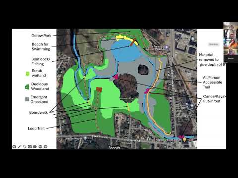
The committee's discussion centered on a 'premium' scenario presented primarily by Malcolm, who shared a map and images showing a roughly 4.5–5.5 acre post-removal pool, deeper channel segments (he estimated 6–9 feet in places), multiple boat launches and docks, a beach area at Juro Park, boardwalks and bridges to enable a circumambulating trail, and wildlife-viewing blinds. He proposed universal "all-person" access paths to connect Giroux, the Bruce Freeman Trail and Commonwealth Avenue, and suggested Scout Island be made canoe-accessible for scouts.
Liz and Vicky emphasized history and interpretation — signage along trails — and accessible viewing platforms. Committee members planned to merge the sketches into a single plan and price amenities individually, with the goal of sequencing work so the town would not need a single large appropriation.
The group repeatedly stressed technical uncertainties. Members debated whether channel manipulation or dredging would be necessary to maintain a navigable, non-choked channel, and named aquatic and shoreline invasives they want to control (phragmites, purple loosestrife, reed canary grass, Japanese knotweed, and water chestnut/milfoil). Committee members said the town will likely need multi-year invasive-management commitments and targeted pretreatment (biocontrols, mesh, edge materials) rather than relying solely on passive recovery.
Committee members also noted ownership and access constraints: a peninsula parcel is town-owned but lacks road frontage, and surrounding cornfields are owned by the Department of Corrections and leased to a farmer — both issues that must be resolved to create continuous public access. The committee agreed to produce two scenario plans for the next meeting: a non‑dredge dam‑removal version showing minimal intervention and an 'amenitized' version that assumes targeted channel manipulation to support docks and deep pools.
Public commenters urged caution and data transparency. Dan, a member of the public, praised the amenities discussion but demanded the town provide explicit physical-condition data (predicted water-surface elevations, groundwater, streamflow and wetland-impact analyses) tied to the 30% design the engineering team is expected to deliver. He warned that schematic renderings risk overstating post-removal wetland extent without rigorous supporting numbers. Other residents raised concerns about siltation of remaining deep holes and the presence of leeches.
The committee voted to approve the previous meeting's minutes at the start of the session and scheduled the next subcommittee meeting to prepare the two scenarios and produce consolidated drawings ahead of a Task Force meeting on the 13th.
The group identified three immediate technical follow-ups for the next meeting: obtain the 30% engineering package, request fisheries and hydrology expertise to assess fish passage and seasonal cold-water conditions for the full year, and produce a prioritized cost/sequencing plan for amenities.
The committee expects to refine the concepts after the 30% design and additional expert briefings.