Get Full Government Meeting Transcripts, Videos, & Alerts Forever!
Get email alerts on the Land Use topic
No spam. Unsubscribe anytime.
Eureka council reviews draft Gulch Greenway ordinance to protect gulches while accommodating state housing requirements
Summary
At a special meeting, the Eureka City Council heard staff and consultant updates on a proposed Gulch Greenway overlay ordinance that would map gulch corridors, require tiered permits for development near streams and steep slopes, and use conservation subdivisions and referrals to CDFW to limit impacts while meeting housing obligations.
Eureka City Council members on the evening of a special meeting received an update on a draft Gulch Greenway Ordinance intended to map and better regulate development in the city's gulches to protect streams, wetlands and riparian habitat while preserving sites identified for housing.
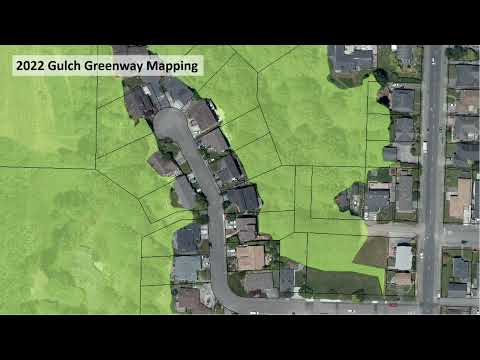
The ordinance proposes a parcel-based Gulch Greenway overlay that would screen properties within roughly 100 feet of steep slopes, riparian drip lines, flood lanes and known wetlands and apply tiered permit requirements ranging from administrative zoning clearances to conditional use permits that would trigger environmental review under the California Environmental Quality Act (CEQA). "We would create a parcel specific map of all of the parcels in Eureka that are within or 100 feet of steep slopes, riparian drip lines, flood lanes, and known streams or wetlands," consultant Ben Noble said during his presentation.
City staff and Noble said the mapping problem is practical and financial: a site-by-site stream and wetland survey to draw precise greenway boundaries is cost-prohibitive at a citywide scale, so the screening-overlay approach is intended to flag parcels for additional review rather than preclude development outright. Director of Development Services Kenyon told council that without special code provisions many residential building permits are currently processed ministerially and therefore do not undergo discretionary review or CEQA assessment, leaving no regulatory tool to prevent further fragmentation of gulch habitat. Staff also reported that over 75% of land in the mapped gulches is privately owned.
Council members focused questions on housing implications. Council member Bauer asked whether parcels identified in the city's housing element are part of the RHNA inventory; staff said the housing element identifies sites for different income bands and that approximately 48 privately owned parcels were identified for moderate and above-moderate housing capacity while many low- and very-low-income units are anticipated on city-owned sites. Noble added the ordinance must be crafted to remain consistent with state housing laws, including the Housing Crisis Act of 2019, so that legally allowed housing densities on vacant residential parcels are not removed by local regulation.
To reduce impacts while preserving housing capacity, staff proposed using tools already in the zoning code, such as conservation subdivisions, which cluster development on upland buildable areas and preserve remaining land as open space. "Conservation subdivisions allow the clustering of development with homes on smaller lots or even multifamily housing types if those units are located on the lot away from natural resources," Noble said. Both staff and council discussed incentives the city might offer to encourage conservation subdivisions, including potential use of housing trust funds or mitigation options such as conservation easements.
Multiple speakers urged collaboration with the California Department of Fish and Wildlife (CDFW). Noble and Kenyon said the updated ordinance will include referral language so CDFW can review ministerial and discretionary permits with potential stream impacts; Noble noted CDFW administers the Section 1600 process for streambed alteration permits. Council member Fernandez and others also discussed the possibility of objective seasonal work limits for streams and wetlands (for example, restricting certain work between June and October) and Noble said timeframes could be added as objective standards.
Public commenters strongly supported the proposal. Jim Clark, a longtime resident, praised the proposed incentives and mitigation options; Katie Rian of CDFW said she authored the agency's letter in the meeting packet and conveyed agency support and willingness to work with the city; Craig Benson, former OSPR member, recommended a clear grandfather clause for existing structures and suggested a simple public guide for living near streams; and Jennifer Caul of Humboldt Water Keeper urged the council not to delay adoption, noting some gulch streams are coho-bearing and drain to Humboldt Bay.
Staff said the current work revises the 2022 draft ordinance and aims to return a revised draft to council in early 2025. Council members endorsed outreach to affected parcel owners, discussed easements or acquisitions as mitigation, and suggested using mapping outputs (APNs) and available datasets'including one-foot contour lidar and recent aerial imagery'to improve screening accuracy. The council adjourned the special meeting and scheduled the next session at 6:00 p.m.
Next steps: staff will draft updated ordinance language incorporating CDFW referral language, consider time-of-year restrictions and objective standards, assemble an APN-based screening map using lidar and 2023 imagery, and return a revised draft to the council for further review.