Get Full Government Meeting Transcripts, Videos, & Alerts Forever!
Get email alerts on the 50 Year Plan Overview topic
No spam. Unsubscribe anytime.
Scappoose consultants say about 59 acres of UGB expansion, 342 acres of urban reserves needed in 50‑year plan
Summary
Consultants told council and planning commissioners the draft 50‑year plan shows about 59 acres needed for UGB expansion and roughly 342 acres for urban reserves (about 400 acres total); study‑area mapping, constraints and a possible 60‑acre rezone were highlighted as factors that could change the final acreage.
Beth Goodman, the consultant leading Scappoose’s 50‑year plan project, told the City Council and Planning Commission that the city’s draft analysis shows a need for roughly 59 acres of urban growth boundary (UGB) expansion and about 342 acres of urban reserves, or about 400 acres total.
Goodman said the findings draw on the housing needs analysis, economic opportunities analysis and a public‑land inventory. She told the group that industrial land supply is adequate but the city faces deficits in commercial, semi‑public and certain residential densities. "UGB expansion, we're looking for about 59 acres. For the urban reserves, we're looking for about 342 acres of land," she said.
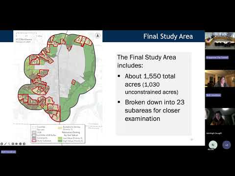
The consultant summarized how staff screened 23 study subareas (about 1,500 acres total, roughly 1,000 acres of which are unconstrained) using statutory priorities and physical constraints: floodplain and floodway, slopes, landslide hazard, and stream buffers. Goodman said adding stream buffers and discounting capacity on smaller lots reduced available capacity by only about 18 acres and that accounting for slopes between 15% and 25% would change capacity by roughly 10 to 20 dwelling units.
City staff and the consultant emphasized that the analysis also models land‑use efficiency measures — such as modest increases in residential density and rezoning specific parcels — that brought projected land need down. Goodman said the analysis used a 3% assumed increase in density across plan designations and noted state law changes that require allowing certain housing types, such as duplexes, in zones previously restricted to single‑family homes.
Officials discussed mapping details and next steps: staff will add road names to the study maps to improve clarity, produce larger printed maps for review and seek Department of Land Conservation and Development (DLCD) guidance on how to count capacity in certain mapped floodplain areas. Goodman said the steering committee’s next meeting will likely be the final advisory meeting and public hearings with the city and county will follow.
No formal motions or votes were taken; councilors and commissioners gave staff direction to continue analysis and to return with clarified maps and legal/technical guidance. The meeting record shows staff asked whether to keep Area 3 in the analysis for now; the group agreed to retain it while staff completes required analyses.