Get Full Government Meeting Transcripts, Videos, & Alerts Forever!
Get email alerts on the Wildfire Map topic
No spam. Unsubscribe anytime.
Morrow County staff warn landowners could be reclassified under new Oregon wildfire-hazard map; appeals routed to state
Summary
County planners briefed commissioners on a statewide wildfire-hazard map under Senate Bill 762, saying the state will finalize the map in coming months, that landowners may be reclassified and that appeals and building-code triggers are managed by state agencies. Staff urged outreach and links to the state appeals process.
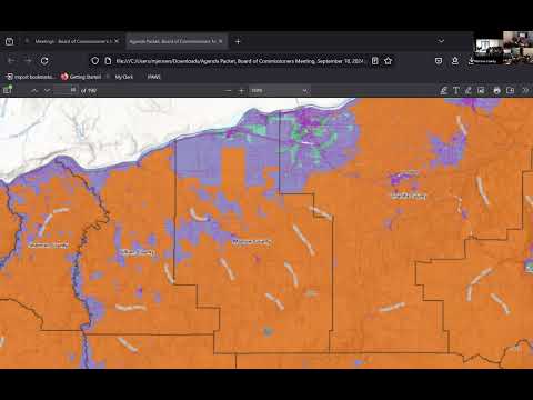
Morrow County planning staff told the Board of Commissioners the Oregon Department of Forestry will issue a finalized statewide wildfire-hazard map in the coming months and that the map will trigger additional building-code requirements for properties mapped in the Wildland-Urban Interface (WUI).
For the record, Planning Director Tamara Mabbit told the board the map is a new regulatory tool tied to Senate Bill 762 and will affect building inspectors and new-structure permitting. "We have nothing to do with it," she said, explaining that appeals and the public-notice process are being handled by the state, not the county. She also emphasized the map'based rules are generally not retroactive except when a property owner makes a "significant improvement" to a structure.
Why it matters: Properties placed in high-risk WUI areas will face fire-hardening requirements when they apply for new permits or make substantial improvements, which can change construction costs and permitting steps. Commissioners and staff said the map also risks misclassifying irrigated or otherwise low-risk parcels because the statewide methodology uses broad data layers and may miss local details.
Commissioners and staff urged practical steps to help residents. They discussed posting guidance and appeal links on the county website and the limits of county action. Several commissioners recommended coordination through the Association of Oregon Counties (AOC) and signaling to the state when multiple counties have similar mapping errors. Staff noted the map was expected to be finalized by Oct. 1 and that a 60-day appeal window would follow the finalization, giving affected property owners a defined period to seek review.
County next steps: Staff said they will forward the state links and outreach information to the board, consider local notice options (website and newspaper of record), and coordinate with AOC where possible. Commissioners asked staff to keep them apprised of any formal appeals or further state guidance on the procedures for correcting map errors.
The board did not take a formal legislative action on the map during the session; commissioners discussed whether to sign any countywide letters of opposition or to bring a formal endorsement to a future agenda.