Get Full Government Meeting Transcripts, Videos, & Alerts Forever!
MassDEP training walks local officials through FEMA coastal flood zones, LIMWA, LOMA/LOMR and site‑plan tips
Summary
MassDEP wetlands staff explained how to read FEMA coastal flood maps — distinguishing VE/AE/AO zones, LIMWA, MOA/MIWA, and letters of map change (LOMA/LOMR) — and gave practitioners practical guidance for delineating flood-zone boundaries on site plans and using FEMA’s online viewer.
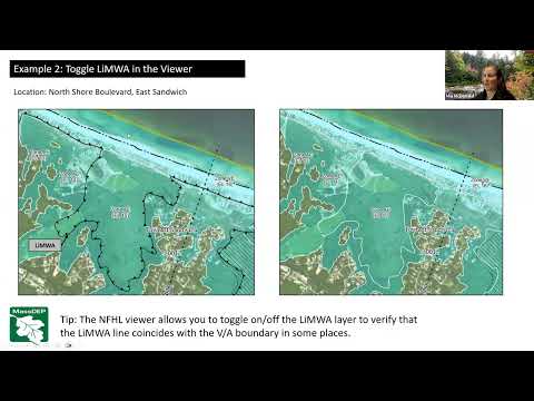
Boston — Officials and coastal planners received a step‑by‑step primer on interpreting FEMA coastal flood maps during a MassDEP wetlands training led by Mia Mcfald, Rebecca Haney and Nate Corcoran.
At the session, Rebecca Haney, a coastal geologist with the Coastal Zone Management Office, said the most hazardous coastal areas are mapped as velocity (VE) zones, which FEMA defines by wave-driven velocity "typically ... based on either wave heights of 3 feet or greater" and where elevations have been determined for base flood elevation. "The VE zone ... that's where you have your waves coming in from the ocean," Haney said, describing how the base flood elevation (BFE) is shown on FEMA maps as the top of water or wave envelope.
Haney described subdivisions of the AE zone used on coastal maps: a moderate wave action area (MOA, also called coastal A)…
Already have an account? Log in
Subscribe to keep reading
Unlock the rest of this article — and every article on Citizen Portal.
- Unlimited articles
- AI-powered breakdowns of topics, speakers, decisions, and budgets
- Instant alerts when your location has a new meeting
- Follow topics and more locations
- 1,000 AI Insights / month, plus AI Chat