Get Full Government Meeting Transcripts, Videos, & Alerts Forever!
Get email alerts on the Flood Mapping topic
No spam. Unsubscribe anytime.
MassDEP training walks local officials through FEMA coastal flood zones, LIMWA, LOMA/LOMR and site‑plan tips
Summary
MassDEP wetlands staff explained how to read FEMA coastal flood maps — distinguishing VE/AE/AO zones, LIMWA, MOA/MIWA, and letters of map change (LOMA/LOMR) — and gave practitioners practical guidance for delineating flood-zone boundaries on site plans and using FEMA’s online viewer.
Boston — Officials and coastal planners received a step‑by‑step primer on interpreting FEMA coastal flood maps during a MassDEP wetlands training led by Mia Mcfald, Rebecca Haney and Nate Corcoran.
At the session, Rebecca Haney, a coastal geologist with the Coastal Zone Management Office, said the most hazardous coastal areas are mapped as velocity (VE) zones, which FEMA defines by wave-driven velocity "typically ... based on either wave heights of 3 feet or greater" and where elevations have been determined for base flood elevation. "The VE zone ... that's where you have your waves coming in from the ocean," Haney said, describing how the base flood elevation (BFE) is shown on FEMA maps as the top of water or wave envelope.
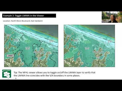
Haney described subdivisions of the AE zone used on coastal maps: a moderate wave action area (MOA, also called coastal A) with roughly 1.5–3.0 foot breaking waves and a minimal wave action area (MIWA) with waves under about 1.5 feet. She noted the Limit of Moderate Wave Action (LIMWA) now appears on Massachusetts FEMA maps after a 2017 coastwide update and that in the FEMA viewer the LIMWA is rendered as a black line with triangles pointing toward higher hazard areas.
Nate Corcoran, a coastal geologist with the MassDEP wetlands program, explained two FEMA map‑change mechanisms: a Letter of Map Amendment (LOMA), which reinterprets existing FIRM information for a specific site, and a Letter of Map Revision (LOMR), a requested map change supported by site‑specific engineering. "If a property owner thinks they're not in a flood zone, they submit more information to FEMA and request a letter of map revision," Corcoran said, noting that changes that make a map less restrictive generally require a formal FEMA map change.
The trainers illustrated multiple coastal examples (East Sandwich, Revere, Winthrop Parkway, Black Pond Road in Plymouth, Salisbury and the New Bedford hurricane barrier) to show how steep topography, seawalls, and local features can produce "invisible" A zones or cause regenerating wave patterns that make mapping complex. Haney said FEMA maps are graphical interpolations based on detailed engineering at widely spaced transects and recommended consulting the underlying Flood Insurance Study available on FEMA's Map Service Center to learn the study date and shoreline conditions used for a particular map.
For local permitting, Haney urged practitioners to place the landward extent of the 1%‑annual‑chance floodplain on site plans using ground elevation (site survey or lidar) rather than simply scaling map overlays. "For the A zone ... you would take that elevation and put that white line at elevation 15 ground contour," she said, giving a concrete example from a plan review. She clarified that these delineation techniques are guidance for local plan review and are not flood‑insurance or mortgage determinations.
The training included hands‑on quizzes using FEMA’s online viewer and volunteer exercises to practice identifying VE/AE/AO labels, LIMWA, and LOMA/LOMR markers. Attendees were shown outreach materials (a story map, poster and a seven‑minute video) available in English, Arabic, Spanish and Portuguese, and MassDEP said slides and the recording would be shared.
The session concluded with an offer to answer questions and with organizers directing participants to FEMA's Map Service Center and MassDEP's wetlands information pages for additional resources.