Revere to install noninvasive flood sensors on Mills Avenue and Belle Isle to alert residents
Loading...
Summary
The Revere Conservation Commission approved a negative determination allowing noninvasive flood-monitoring sensors and tide gauges to be installed at Mills Avenue, Belle Isle Marsh and Remedy Marsh; the project is grant-funded and will feed a public alert platform.
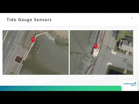
The Revere Conservation Commission on Tuesday approved a negative determination of applicability that clears the way for installation of noninvasive flood-monitoring sensors and tide gauges at two marsh-adjacent neighborhoods, Mills Avenue and Belle Isle (also expanded to include Remedy Marsh).
Kristen Hoemeyer, Revere’s resilience manager, and Justine Rooney, coastal scientist with the Woods Hole Group, told the commission the project’s phase two is funded by two grants — the Coastal Zone Management (CZM) Fiscal Year ’26 Coastal Resilience Grant and the Metropolitan Area Planning Council’s Accelerating Climate Resilience grant — and is intended to give residents early warning to move vehicles and prepare for high-tide and sunny‑day flooding.
Rooney described the sensors as Hohonu ultrasonic devices about 36 centimeters tall that mount above the water on existing structures such as bridges and utility poles. She said the devices are designed to be small and nonintrusive and “do not fill, remove, dredge, or otherwise alter any portion of any resource under the Wetlands Protection Act.” Data from the devices will feed a cloud-hosted platform (the Hohonu platform), which the presenters said will be owned by the city of Revere and can be made available to neighboring communities.
The presenters said the four sensors for the two systems are covered by grant funding for installation. Ongoing data-platform costs for the two overland sensors mounted on utility poles were described as roughly $5,000 per sensor per year; the planning department has committed to funding that platform cost in perpetuity. Rooney said existing monitoring in nearby communities indicates frequent roadway inundation; she referenced preliminary analysis suggesting Mills Avenue flooded about 400 times in 10 years, and said the new sensors will validate and quantify flooding frequency.
Commissioners and attendees asked technical questions about power, battery chemistry and data transmission. Rooney and staff said the units are solar powered, transmit data to the cloud in near-real time (likely using cellular networks such as LTE/5G), and that vendor support and routine checks would be part of the maintenance plan. The presenters committed to provide more details on the battery type and connectivity.
The commission heard public support for the project and noted the installation’s minimal wetland impact. After discussion, a motion for a negative determination of applicability passed, allowing the noninvasive monitoring installations to proceed under the conditions described to the commission.
What’s next: presenters said they will return with a report validating historical claims about flooding frequency, publish outreach materials (a web toolkit, postcards and a newsletter), and keep the commission informed of installation timing and monitoring results.