Get Full Government Meeting Transcripts, Videos, & Alerts Forever!
Eugene staff outline methodology shifts for 2027 buildable lands inventory, propose 30% slope cutoff
Summary
City planning staff told the Envision Eugene technical advisory committee they will run a 2027 Buildable Lands Inventory using new 2023 lidar and parcel-specific data, keep a $1,000 assessor-improvement threshold, and continue using a 30% predominant-slope cutoff for residential/commercial capacity calculations.
The Envision Eugene technical advisory committee on Dec. 4 heard a technical briefing from Thea Evans, a senior GIS analyst in the city planning division, on how staff will run and classify lands for the 2027 Buildable Lands Inventory (BLI).
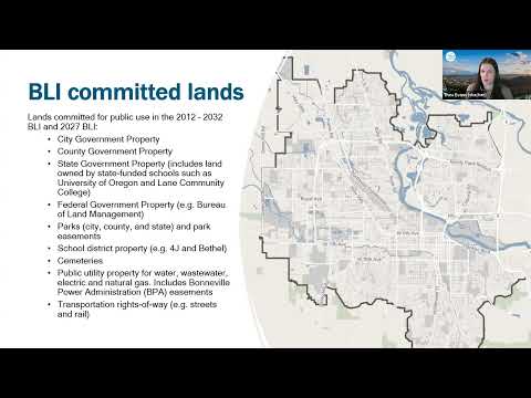
Evans said the city will run the model in January 2026 and update it in January 2027, with an effective date of Jan. 1, 2027 and adoption expected by December 2027. The BLI will classify every tax lot inside the urban growth boundary into five categories — committed, constrained, developed, partially vacant and undeveloped — and then estimate residential and employment capacity on the buildable portions of those lots. "It's going to be very technical, very in the weeds," Evans said as she began the presentation.
Staff emphasized improved data inputs. The BLI will use new 2023 lidar-derived elevation data and parcel-specific land-use and zoning designations rather than the older county-level land-use layer used in…
Already have an account? Log in
Subscribe to keep reading
Unlock the rest of this article — and every article on Citizen Portal.
- Unlimited articles
- AI-powered breakdowns of topics, speakers, decisions, and budgets
- Instant alerts when your location has a new meeting
- Follow topics and more locations
- 1,000 AI Insights / month, plus AI Chat