Get Full Government Meeting Transcripts, Videos, & Alerts Forever!
Rutland Regional Planning Commission revises regional future land use map after LURB feedback
Summary
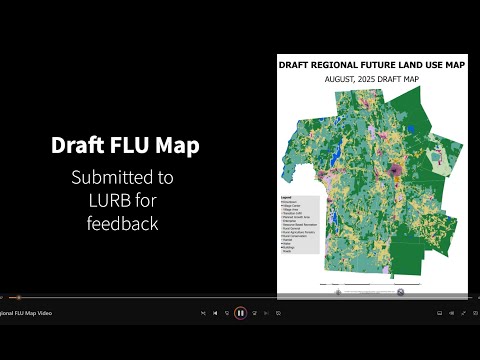
The Rutland Regional Planning Commission updated its regional future land use map to align boundaries to parcel lines, consolidate fragmented rural categories, and adjust village and planned growth area boundaries after written feedback from the Vermont Land Use Review Board (LURB).
The Rutland Regional Planning Commission released a video explaining revisions to its regional future land use map after written feedback from the Vermont Land Use Review Board (LURB). The presenter said the changes emphasize parcel-aligned boundaries, clearer rural categories, and recategorization of some village areas to better reflect state planning intent and designation requirements.
The presenter said the RRPC developed a pre-application map in coordination with all 27 municipalities in the region and submitted it to LURB for review. LURB’s regionwide guidance, the presenter said, called for simpler, smoother boundaries and removal of narrow or unusual slivers created by…
Already have an account? Log in
Subscribe to keep reading
Unlock the rest of this article — and every article on Citizen Portal.
- Unlimited articles
- AI-powered breakdowns of topics, speakers, decisions, and budgets
- Instant alerts when your location has a new meeting
- Follow topics and more locations
- 1,000 AI Insights / month, plus AI Chat